You are here: Home > Network List > CI - Caltech Regional Seismic Network Stations List
> Station GSC Goldstone, California, USA > Earthquake Result Viewer
GSC Goldstone, California, USA - Earthquake Result Viewer
| Earthquake location: |
Northern Peru |
| Earthquake latitude/longitude: |
-4.4/-76.7 |
| Earthquake time(UTC): |
1997/10/28 (301) 06:15:17 GMT |
| Earthquake Depth: |
112 km |
| Earthquake Magnitude: |
6.6 MB, 6.3 MS, 7.2 UNKNOWN, 6.6 ME |
| Earthquake Catalog/Contributor: |
WHDF/NEIC |
|
| Network: |
CI Caltech Regional Seismic Network |
| Station: |
GSC Goldstone, California, USA |
| Lat/Lon: |
35.30 N/116.81 W |
| Elevation: |
954 m |
|
| Distance: |
54.5 deg |
| Az: |
319.673 deg |
| Baz: |
127.915 deg |
| Ray Param: |
0.06503161 |
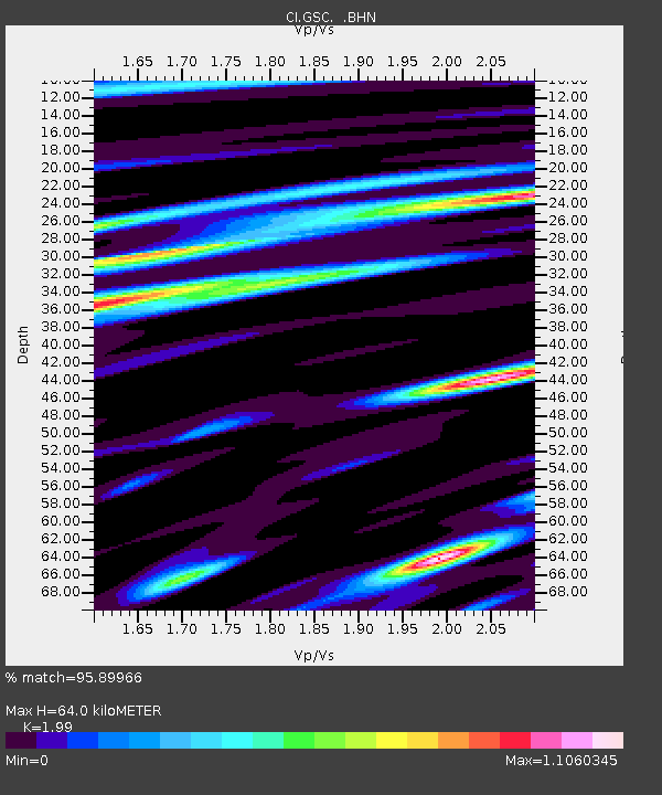
| Estimated Moho Depth: |
64.0 km |
| Estimated Crust Vp/Vs: |
1.99 |
| Assumed Crust Vp: |
6.276 km/s |
| Estimated Crust Vs: |
3.154 km/s |
| Estimated Crust Poisson's Ratio: |
0.33 |
|
| Radial Match: |
95.89966 % |
| Radial Bump: |
348 |
| Transverse Match: |
85.655556 % |
| Transverse Bump: |
400 |
| SOD ConfigId: |
4770 |
| Insert Time: |
2010-02-25 23:45:04.772 +0000 |
| GWidth: |
2.5 |
| Max Bumps: |
400 |
| Tol: |
0.001 |
|
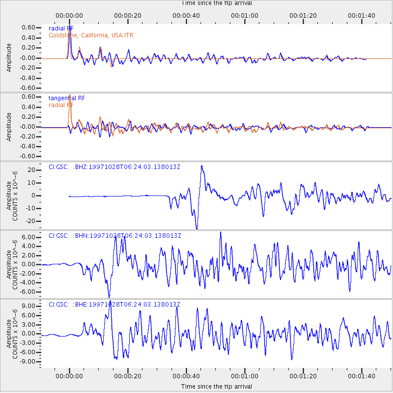
Signal To Noise
| Channel | StoN | STA | LTA |
| CI:GSC: :BHN:19971028T06:24:03.138013Z | 3.846179 | 5.100193E-7 | 1.3260414E-7 |
| CI:GSC: :BHE:19971028T06:24:03.138013Z | 3.4101825 | 5.267581E-7 | 1.5446624E-7 |
| CI:GSC: :BHZ:19971028T06:24:03.138013Z | 12.721326 | 2.3269472E-6 | 1.8291705E-7 |
| Arrivals |
| Ps | 11 SECOND |
| PpPs | 29 SECOND |
| PsPs/PpSs | 40 SECOND |


