You are here: Home > Network List > PR - Puerto Rico Seismic Network (PRSN) & Puerto Rico Strong Motion Program (PRSMP) Stations List
> Station ABVI Anegada, BVI > Earthquake Result Viewer
ABVI Anegada, BVI - Earthquake Result Viewer
| Earthquake location: |
Near Coast Of Central Chile |
| Earthquake latitude/longitude: |
-31.2/-71.6 |
| Earthquake time(UTC): |
2015/09/17 (260) 01:41:09 GMT |
| Earthquake Depth: |
37 km |
| Earthquake Magnitude: |
5.6 MB |
| Earthquake Catalog/Contributor: |
NEIC PDE/NEIC COMCAT |
|
| Network: |
PR Puerto Rico Seismic Network (PRSN) & Puerto Rico Strong Motion Program (PRSMP) |
| Station: |
ABVI Anegada, BVI |
| Lat/Lon: |
18.73 N/64.33 W |
| Elevation: |
8.0 m |
|
| Distance: |
50.1 deg |
| Az: |
8.999 deg |
| Baz: |
188.135 deg |
| Ray Param: |
0.06821206 |
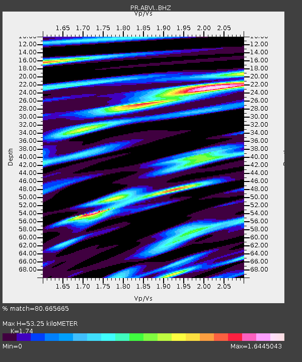
| Estimated Moho Depth: |
53.25 km |
| Estimated Crust Vp/Vs: |
1.74 |
| Assumed Crust Vp: |
5.14 km/s |
| Estimated Crust Vs: |
2.954 km/s |
| Estimated Crust Poisson's Ratio: |
0.25 |
|
| Radial Match: |
80.665665 % |
| Radial Bump: |
400 |
| Transverse Match: |
61.246082 % |
| Transverse Bump: |
400 |
| SOD ConfigId: |
7422571 |
| Insert Time: |
2019-04-20 20:24:22.990 +0000 |
| GWidth: |
2.5 |
| Max Bumps: |
400 |
| Tol: |
0.001 |
|

Signal To Noise
| Channel | StoN | STA | LTA |
| PR:ABVI: :BHZ:20150917T01:49:25.725001Z | 1.7673471 | 5.852198E-6 | 3.3112894E-6 |
| PR:ABVI: :BHN:20150917T01:49:25.725001Z | 0.7962737 | 2.597779E-6 | 3.2624198E-6 |
| PR:ABVI: :BHE:20150917T01:49:25.725001Z | 0.5752358 | 1.4313364E-6 | 2.4882602E-6 |
| Arrivals |
| Ps | 8.0 SECOND |
| PpPs | 27 SECOND |
| PsPs/PpSs | 35 SECOND |


