You are here: Home > Network List > TA - USArray Transportable Network (new EarthScope stations) Stations List
> Station M54A Oil Creek State Park, Oil City, PA, USA > Earthquake Result Viewer
M54A Oil Creek State Park, Oil City, PA, USA - Earthquake Result Viewer
| Earthquake location: |
Near Coast Of Central Chile |
| Earthquake latitude/longitude: |
-31.2/-71.6 |
| Earthquake time(UTC): |
2015/09/17 (260) 01:41:09 GMT |
| Earthquake Depth: |
37 km |
| Earthquake Magnitude: |
5.6 MB |
| Earthquake Catalog/Contributor: |
NEIC PDE/NEIC COMCAT |
|
| Network: |
TA USArray Transportable Network (new EarthScope stations) |
| Station: |
M54A Oil Creek State Park, Oil City, PA, USA |
| Lat/Lon: |
41.51 N/79.66 W |
| Elevation: |
488 m |
|
| Distance: |
72.7 deg |
| Az: |
353.668 deg |
| Baz: |
172.767 deg |
| Ray Param: |
0.05344161 |
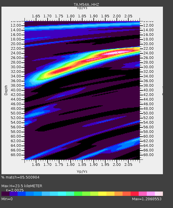
| Estimated Moho Depth: |
23.5 km |
| Estimated Crust Vp/Vs: |
2.00 |
| Assumed Crust Vp: |
6.121 km/s |
| Estimated Crust Vs: |
3.056 km/s |
| Estimated Crust Poisson's Ratio: |
0.33 |
|
| Radial Match: |
85.500984 % |
| Radial Bump: |
322 |
| Transverse Match: |
61.98595 % |
| Transverse Bump: |
235 |
| SOD ConfigId: |
7422571 |
| Insert Time: |
2019-04-20 20:24:48.910 +0000 |
| GWidth: |
2.5 |
| Max Bumps: |
400 |
| Tol: |
0.001 |
|

Signal To Noise
| Channel | StoN | STA | LTA |
| TA:M54A: :HHZ:20150917T01:51:58.059993Z | 0.9232368 | 4.2277757E-6 | 4.579297E-6 |
| TA:M54A: :HHN:20150917T01:51:58.059993Z | 0.5020082 | 2.1280189E-6 | 4.239012E-6 |
| TA:M54A: :HHE:20150917T01:51:58.059993Z | 2.0947733 | 3.3959009E-6 | 1.6211305E-6 |
| Arrivals |
| Ps | 4.0 SECOND |
| PpPs | 11 SECOND |
| PsPs/PpSs | 15 SECOND |


