You are here: Home > Network List > US - United States National Seismic Network Stations List
> Station WMOK Wichita Mountains, Oklahoma, USA > Earthquake Result Viewer
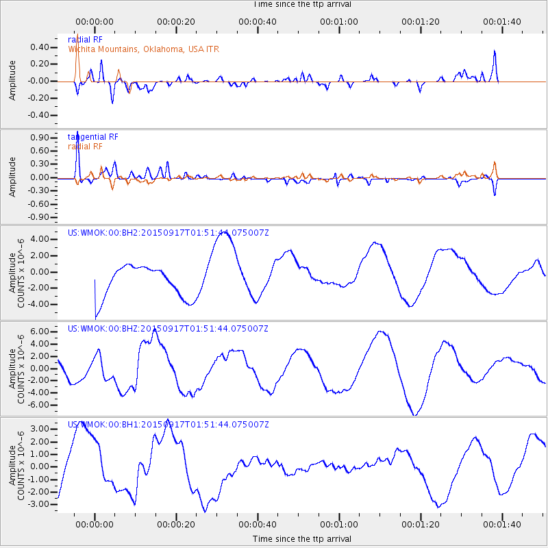
WMOK Wichita Mountains, Oklahoma, USA - Earthquake Result Viewer
*The percent match for this event was below the threshold and hence no stack was calculated.
| Earthquake location: |
Near Coast Of Central Chile |
| Earthquake latitude/longitude: |
-31.2/-71.6 |
| Earthquake time(UTC): |
2015/09/17 (260) 01:41:09 GMT |
| Earthquake Depth: |
37 km |
| Earthquake Magnitude: |
5.6 MB |
| Earthquake Catalog/Contributor: |
NEIC PDE/NEIC COMCAT |
|
| Network: |
US United States National Seismic Network |
| Station: |
WMOK Wichita Mountains, Oklahoma, USA |
| Lat/Lon: |
34.74 N/98.78 W |
| Elevation: |
486 m |
|
| Distance: |
70.4 deg |
| Az: |
336.461 deg |
| Baz: |
155.434 deg |
| Ray Param: |
$rayparam |
*The percent match for this event was below the threshold and hence was not used in the summary stack. |
|
| Radial Match: |
59.16144 % |
| Radial Bump: |
400 |
| Transverse Match: |
47.400215 % |
| Transverse Bump: |
400 |
| SOD ConfigId: |
7422571 |
| Insert Time: |
2019-04-20 20:25:28.701 +0000 |
| GWidth: |
2.5 |
| Max Bumps: |
400 |
| Tol: |
0.001 |
|
Signal To Noise
| Channel | StoN | STA | LTA |
| US:WMOK:00:BHZ:20150917T01:51:44.075007Z | 0.740657 | 1.9278539E-6 | 2.602897E-6 |
| US:WMOK:00:BH1:20150917T01:51:44.075007Z | 0.75121737 | 1.8917955E-6 | 2.5183062E-6 |
| US:WMOK:00:BH2:20150917T01:51:44.075007Z | 1.4973243 | 2.586498E-6 | 1.7274134E-6 |
| Arrivals |
| Ps | |
| PpPs | |
| PsPs/PpSs | |


