You are here: Home > Network List > IU - Global Seismograph Network (GSN - IRIS/USGS) Stations List
> Station TUC Tucson, Arizona > Earthquake Result Viewer
TUC Tucson, Arizona - Earthquake Result Viewer

| Earthquake location: |
Southeast Of Loyalty Islands |
| Earthquake latitude/longitude: |
-22.0/170.1 |
| Earthquake time(UTC): |
2001/02/28 (059) 13:05:31 GMT |
| Earthquake Depth: |
10 km |
| Earthquake Magnitude: |
5.8 MB, 6.1 MS, 6.2 MW |
| Earthquake Catalog/Contributor: |
WHDF/NEIC |
|
| Network: |
IU Global Seismograph Network (GSN - IRIS/USGS) |
| Station: |
TUC Tucson, Arizona |
| Lat/Lon: |
32.31 N/110.78 W |
| Elevation: |
874 m |
|
| Distance: |
92.8 deg |
| Az: |
56.362 deg |
| Baz: |
245.845 deg |
| Ray Param: |
0.041378018 |
| Estimated Moho Depth: |
47.0 km |
| Estimated Crust Vp/Vs: |
1.70 |
| Assumed Crust Vp: |
6.276 km/s |
| Estimated Crust Vs: |
3.692 km/s |
| Estimated Crust Poisson's Ratio: |
0.24 |
|
| Radial Match: |
99.10848 % |
| Radial Bump: |
261 |
| Transverse Match: |
84.45149 % |
| Transverse Bump: |
343 |
| SOD ConfigId: |
3744 |
| Insert Time: |
2010-03-04 19:48:54.597 +0000 |
| GWidth: |
2.5 |
| Max Bumps: |
400 |
| Tol: |
0.001 |
|
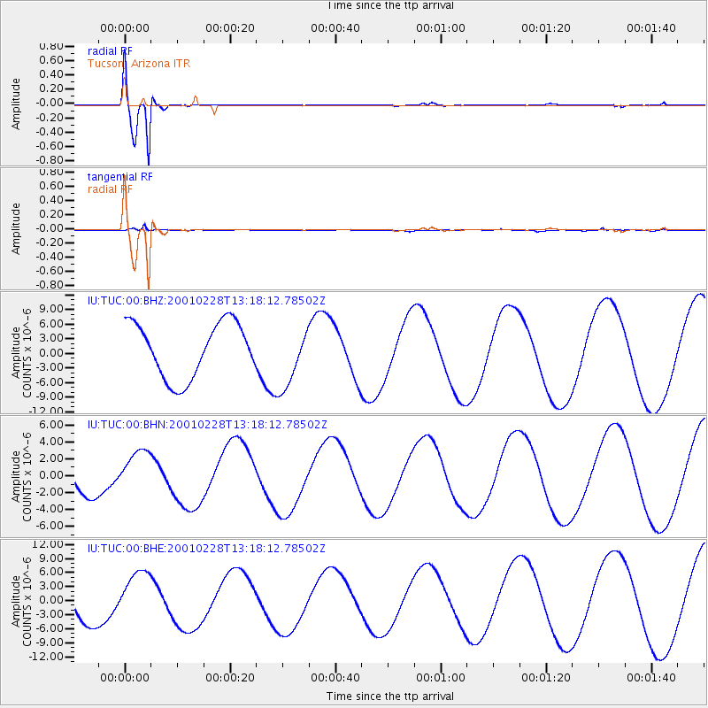
Signal To Noise
| Channel | StoN | STA | LTA |
| IU:TUC:00:BHN:20010228T13:18:12.78502Z | 1.5740212 | 2.7553751E-6 | 1.7505323E-6 |
| IU:TUC:00:BHE:20010228T13:18:12.78502Z | 1.5245386 | 5.765378E-6 | 3.78172E-6 |
| IU:TUC:00:BHZ:20010228T13:18:12.78502Z | 1.1116551 | 6.203723E-6 | 5.5806186E-6 |
| Arrivals |
| Ps | 5.3 SECOND |
| PpPs | 20 SECOND |
| PsPs/PpSs | 25 SECOND |


