You are here: Home > Network List > WI - West Indies IPGP Network Stations List
> Station MAGL Barre de l'ile, Marie-Galante, Guadeloupe > Earthquake Result Viewer
MAGL Barre de l'ile, Marie-Galante, Guadeloupe - Earthquake Result Viewer
| Earthquake location: |
Near Coast Of Central Chile |
| Earthquake latitude/longitude: |
-31.2/-71.6 |
| Earthquake time(UTC): |
2015/09/17 (260) 01:41:09 GMT |
| Earthquake Depth: |
37 km |
| Earthquake Magnitude: |
5.6 MB |
| Earthquake Catalog/Contributor: |
NEIC PDE/NEIC COMCAT |
|
| Network: |
WI West Indies IPGP Network |
| Station: |
MAGL Barre de l'ile, Marie-Galante, Guadeloupe |
| Lat/Lon: |
15.95 N/61.28 W |
| Elevation: |
159 m |
|
| Distance: |
47.9 deg |
| Az: |
13.441 deg |
| Baz: |
191.956 deg |
| Ray Param: |
0.06964002 |
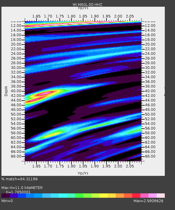
| Estimated Moho Depth: |
11.0 km |
| Estimated Crust Vp/Vs: |
1.79 |
| Assumed Crust Vp: |
5.88 km/s |
| Estimated Crust Vs: |
3.294 km/s |
| Estimated Crust Poisson's Ratio: |
0.27 |
|
| Radial Match: |
84.31196 % |
| Radial Bump: |
400 |
| Transverse Match: |
52.443428 % |
| Transverse Bump: |
400 |
| SOD ConfigId: |
7422571 |
| Insert Time: |
2019-04-20 20:25:52.304 +0000 |
| GWidth: |
2.5 |
| Max Bumps: |
400 |
| Tol: |
0.001 |
|
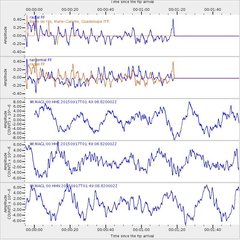
Signal To Noise
| Channel | StoN | STA | LTA |
| WI:MAGL:00:HHZ:20150917T01:49:08.820002Z | 1.20456 | 3.7517214E-6 | 3.114599E-6 |
| WI:MAGL:00:HHN:20150917T01:49:08.820002Z | 1.2562397 | 4.7144968E-6 | 3.752864E-6 |
| WI:MAGL:00:HHE:20150917T01:49:08.820002Z | 1.2066923 | 4.389655E-6 | 3.6377583E-6 |
| Arrivals |
| Ps | 1.5 SECOND |
| PpPs | 5.0 SECOND |
| PsPs/PpSs | 6.5 SECOND |


