You are here: Home > Network List > IU - Global Seismograph Network (GSN - IRIS/USGS) Stations List
> Station TUC Tucson, Arizona > Earthquake Result Viewer
TUC Tucson, Arizona - Earthquake Result Viewer

| Earthquake location: |
Near Coast Of Peru |
| Earthquake latitude/longitude: |
-17.5/-72.1 |
| Earthquake time(UTC): |
2001/07/07 (188) 09:38:43 GMT |
| Earthquake Depth: |
33 km |
| Earthquake Magnitude: |
6.6 MB, 7.3 MS, 7.6 MW, 7.5 ME |
| Earthquake Catalog/Contributor: |
WHDF/NEIC |
|
| Network: |
IU Global Seismograph Network (GSN - IRIS/USGS) |
| Station: |
TUC Tucson, Arizona |
| Lat/Lon: |
32.31 N/110.78 W |
| Elevation: |
874 m |
|
| Distance: |
61.9 deg |
| Az: |
323.107 deg |
| Baz: |
137.439 deg |
| Ray Param: |
0.06052955 |
| Estimated Moho Depth: |
29.25 km |
| Estimated Crust Vp/Vs: |
1.90 |
| Assumed Crust Vp: |
6.276 km/s |
| Estimated Crust Vs: |
3.307 km/s |
| Estimated Crust Poisson's Ratio: |
0.31 |
|
| Radial Match: |
97.368675 % |
| Radial Bump: |
160 |
| Transverse Match: |
87.49814 % |
| Transverse Bump: |
400 |
| SOD ConfigId: |
4714 |
| Insert Time: |
2010-03-04 19:49:11.781 +0000 |
| GWidth: |
2.5 |
| Max Bumps: |
400 |
| Tol: |
0.001 |
|
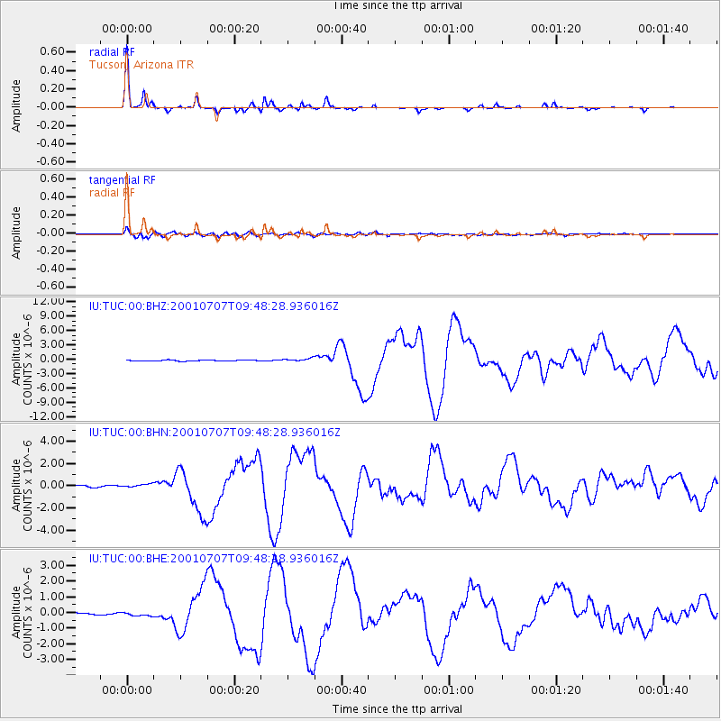
Signal To Noise
| Channel | StoN | STA | LTA |
| IU:TUC:00:BHN:20010707T09:48:28.936016Z | 2.1627204 | 1.7284877E-7 | 7.9921925E-8 |
| IU:TUC:00:BHE:20010707T09:48:28.936016Z | 2.6045341 | 1.286558E-7 | 4.9396856E-8 |
| IU:TUC:00:BHZ:20010707T09:48:28.936016Z | 3.5928965 | 3.3303326E-7 | 9.269214E-8 |
| Arrivals |
| Ps | 4.4 SECOND |
| PpPs | 13 SECOND |
| PsPs/PpSs | 17 SECOND |


