You are here: Home > Network List > GS - US Geological Survey Networks Stations List
> Station OK031 2598 S. Brethren Rd., Cushing, OK, USA > Earthquake Result Viewer
OK031 2598 S. Brethren Rd., Cushing, OK, USA - Earthquake Result Viewer
| Earthquake location: |
Southeast Of Honshu, Japan |
| Earthquake latitude/longitude: |
31.2/142.4 |
| Earthquake time(UTC): |
2015/05/10 (130) 21:25:46 GMT |
| Earthquake Depth: |
18 km |
| Earthquake Magnitude: |
5.6 MB |
| Earthquake Catalog/Contributor: |
NEIC PDE/NEIC COMCAT |
|
| Network: |
GS US Geological Survey Networks |
| Station: |
OK031 2598 S. Brethren Rd., Cushing, OK, USA |
| Lat/Lon: |
35.95 N/96.84 W |
| Elevation: |
290 m |
|
| Distance: |
93.1 deg |
| Az: |
44.271 deg |
| Baz: |
312.535 deg |
| Ray Param: |
0.04132539 |
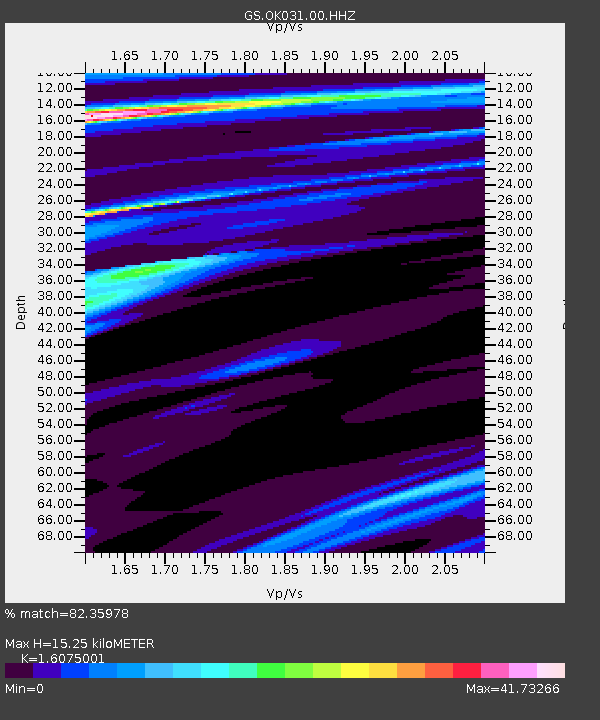
| Estimated Moho Depth: |
15.25 km |
| Estimated Crust Vp/Vs: |
1.61 |
| Assumed Crust Vp: |
6.426 km/s |
| Estimated Crust Vs: |
3.998 km/s |
| Estimated Crust Poisson's Ratio: |
0.18 |
|
| Radial Match: |
82.35978 % |
| Radial Bump: |
307 |
| Transverse Match: |
87.89092 % |
| Transverse Bump: |
228 |
| SOD ConfigId: |
976571 |
| Insert Time: |
2015-05-24 21:53:22.131 +0000 |
| GWidth: |
2.5 |
| Max Bumps: |
400 |
| Tol: |
0.001 |
|
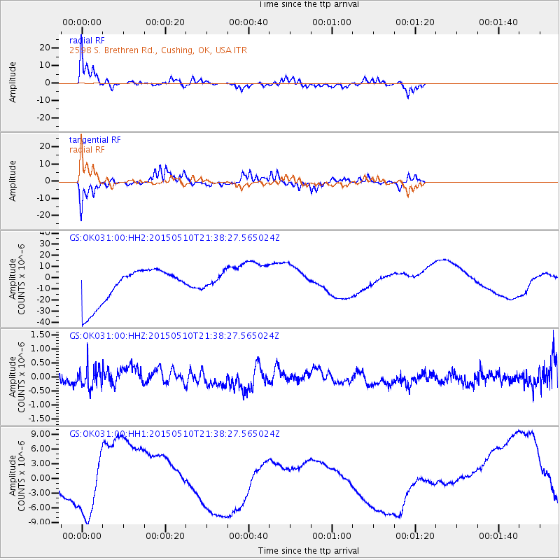
Signal To Noise
| Channel | StoN | STA | LTA |
| GS:OK031:00:HHZ:20150510T21:38:27.565024Z | 1.527628 | 3.7285017E-7 | 2.4407132E-7 |
| GS:OK031:00:HH1:20150510T21:38:27.565024Z | 0.596795 | 4.746517E-6 | 7.953346E-6 |
| GS:OK031:00:HH2:20150510T21:38:27.565024Z | 0.46778142 | 7.369014E-6 | 1.5753114E-5 |
| Arrivals |
| Ps | 1.5 SECOND |
| PpPs | 6.1 SECOND |
| PsPs/PpSs | 7.5 SECOND |


