You are here: Home > Network List > GS - US Geological Survey Networks Stations List
> Station DEC12 Decatur Surface Seismic Site, Decatur, IL, USA > Earthquake Result Viewer
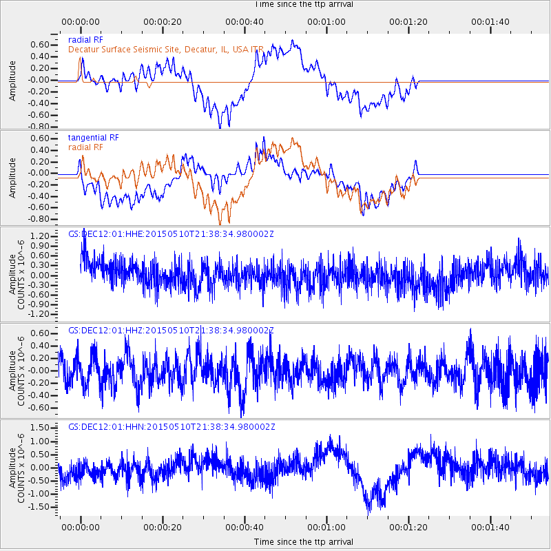
DEC12 Decatur Surface Seismic Site, Decatur, IL, USA - Earthquake Result Viewer
*The percent match for this event was below the threshold and hence no stack was calculated.
| Earthquake location: |
Southeast Of Honshu, Japan |
| Earthquake latitude/longitude: |
31.2/142.4 |
| Earthquake time(UTC): |
2015/05/10 (130) 21:25:46 GMT |
| Earthquake Depth: |
18 km |
| Earthquake Magnitude: |
5.6 MB |
| Earthquake Catalog/Contributor: |
NEIC PDE/NEIC COMCAT |
|
| Network: |
GS US Geological Survey Networks |
| Station: |
DEC12 Decatur Surface Seismic Site, Decatur, IL, USA |
| Lat/Lon: |
39.91 N/88.91 W |
| Elevation: |
208 m |
|
| Distance: |
94.7 deg |
| Az: |
37.027 deg |
| Baz: |
317.893 deg |
| Ray Param: |
$rayparam |
*The percent match for this event was below the threshold and hence was not used in the summary stack. |
|
| Radial Match: |
53.857437 % |
| Radial Bump: |
400 |
| Transverse Match: |
57.71763 % |
| Transverse Bump: |
400 |
| SOD ConfigId: |
976571 |
| Insert Time: |
2015-05-24 21:53:46.344 +0000 |
| GWidth: |
2.5 |
| Max Bumps: |
400 |
| Tol: |
0.001 |
|
Signal To Noise
| Channel | StoN | STA | LTA |
| GS:DEC12:01:HHZ:20150510T21:38:34.980002Z | 1.3761076 | 2.471044E-7 | 1.7956766E-7 |
| GS:DEC12:01:HHN:20150510T21:38:34.980002Z | 1.1322103 | 3.5973466E-7 | 3.177278E-7 |
| GS:DEC12:01:HHE:20150510T21:38:34.980002Z | 0.9991381 | 3.5630012E-7 | 3.5660747E-7 |
| Arrivals |
| Ps | |
| PpPs | |
| PsPs/PpSs | |


