You are here: Home > Network List > IU - Global Seismograph Network (GSN - IRIS/USGS) Stations List
> Station ANMO Albuquerque, New Mexico, USA > Earthquake Result Viewer
ANMO Albuquerque, New Mexico, USA - Earthquake Result Viewer
| Earthquake location: |
Southern Bolivia |
| Earthquake latitude/longitude: |
-19.3/-66.6 |
| Earthquake time(UTC): |
1990/10/10 (283) 01:00:06 GMT |
| Earthquake Depth: |
271 km |
| Earthquake Magnitude: |
5.8 MB, 6.4 UNKNOWN |
| Earthquake Catalog/Contributor: |
WHDF/NEIC |
|
| Network: |
IU Global Seismograph Network (GSN - IRIS/USGS) |
| Station: |
ANMO Albuquerque, New Mexico, USA |
| Lat/Lon: |
34.95 N/106.46 W |
| Elevation: |
1840 m |
|
| Distance: |
66.0 deg |
| Az: |
324.757 deg |
| Baz: |
138.449 deg |
| Ray Param: |
0.057087105 |
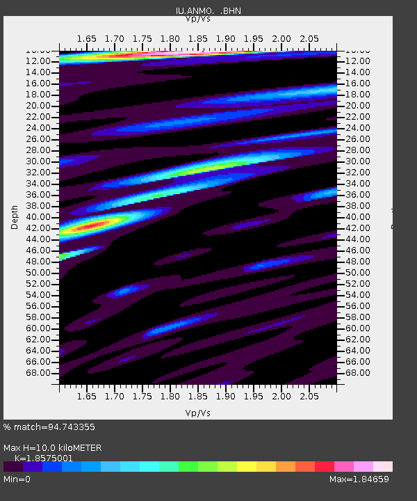
| Estimated Moho Depth: |
10.0 km |
| Estimated Crust Vp/Vs: |
1.86 |
| Assumed Crust Vp: |
6.502 km/s |
| Estimated Crust Vs: |
3.5 km/s |
| Estimated Crust Poisson's Ratio: |
0.30 |
|
| Radial Match: |
94.743355 % |
| Radial Bump: |
303 |
| Transverse Match: |
74.42191 % |
| Transverse Bump: |
400 |
| SOD ConfigId: |
17000 |
| Insert Time: |
2010-03-04 19:51:10.744 +0000 |
| GWidth: |
2.5 |
| Max Bumps: |
400 |
| Tol: |
0.001 |
|

Signal To Noise
| Channel | StoN | STA | LTA |
| IU:ANMO: :BHN:19901010T01:09:52.997009Z | 5.4075084 | 2.327522E-7 | 4.3042412E-8 |
| IU:ANMO: :BHE:19901010T01:09:52.997009Z | 4.0812616 | 2.8501347E-7 | 6.983465E-8 |
| IU:ANMO: :BHZ:19901010T01:09:52.997009Z | 8.219852 | 5.4547326E-7 | 6.636048E-8 |
| Arrivals |
| Ps | 1.4 SECOND |
| PpPs | 4.2 SECOND |
| PsPs/PpSs | 5.6 SECOND |


