You are here: Home > Network List > IU - Global Seismograph Network (GSN - IRIS/USGS) Stations List
> Station ANMO Albuquerque, New Mexico, USA > Earthquake Result Viewer
ANMO Albuquerque, New Mexico, USA - Earthquake Result Viewer
| Earthquake location: |
Peru-Brazil Border Region |
| Earthquake latitude/longitude: |
-11.0/-70.8 |
| Earthquake time(UTC): |
1990/10/17 (290) 14:30:14 GMT |
| Earthquake Depth: |
624 km |
| Earthquake Magnitude: |
6.7 MB, 6.8 UNKNOWN |
| Earthquake Catalog/Contributor: |
WHDF/NEIC |
|
| Network: |
IU Global Seismograph Network (GSN - IRIS/USGS) |
| Station: |
ANMO Albuquerque, New Mexico, USA |
| Lat/Lon: |
34.95 N/106.46 W |
| Elevation: |
1840 m |
|
| Distance: |
56.8 deg |
| Az: |
325.081 deg |
| Baz: |
136.829 deg |
| Ray Param: |
0.0612151 |
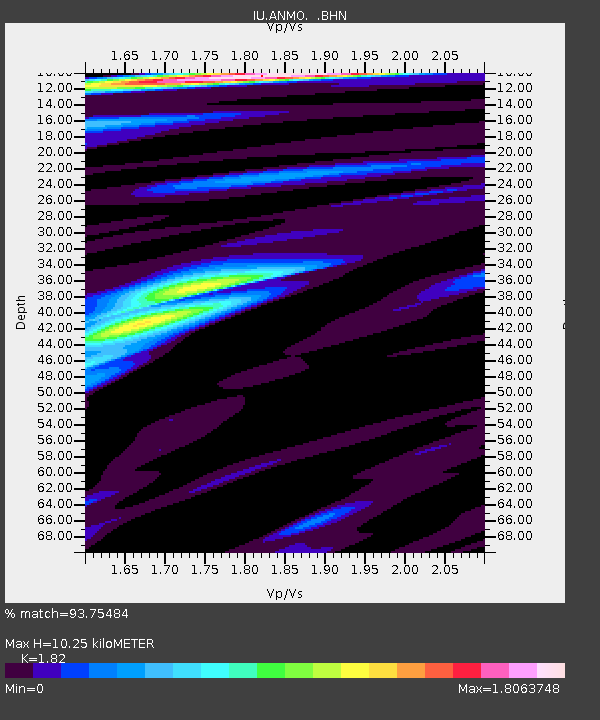
| Estimated Moho Depth: |
10.25 km |
| Estimated Crust Vp/Vs: |
1.82 |
| Assumed Crust Vp: |
6.502 km/s |
| Estimated Crust Vs: |
3.572 km/s |
| Estimated Crust Poisson's Ratio: |
0.28 |
|
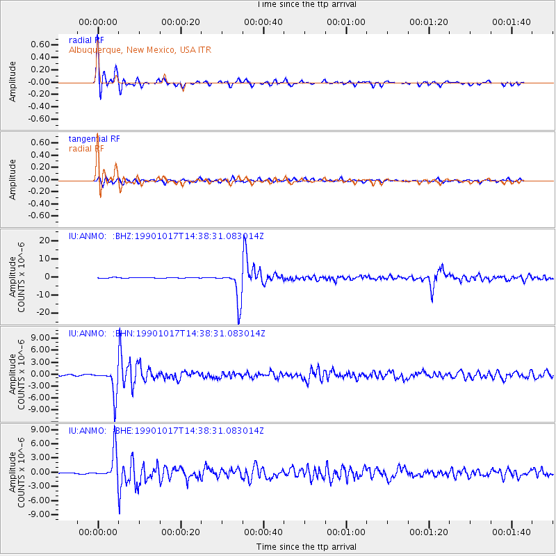
| Radial Match: |
93.75484 % |
| Radial Bump: |
396 |
| Transverse Match: |
84.95505 % |
| Transverse Bump: |
400 |
| SOD ConfigId: |
17000 |
| Insert Time: |
2010-03-04 19:51:11.979 +0000 |
| GWidth: |
2.5 |
| Max Bumps: |
400 |
| Tol: |
0.001 |
|
Signal To Noise
| Channel | StoN | STA | LTA |
| IU:ANMO: :BHN:19901017T14:38:31.083014Z | 26.89893 | 3.4974964E-6 | 1.3002364E-7 |
| IU:ANMO: :BHE:19901017T14:38:31.083014Z | 16.381598 | 3.1733646E-6 | 1.9371522E-7 |
| IU:ANMO: :BHZ:19901017T14:38:31.083014Z | 56.343975 | 9.205611E-6 | 1.6338234E-7 |
| Arrivals |
| Ps | 1.4 SECOND |
| PpPs | 4.2 SECOND |
| PsPs/PpSs | 5.6 SECOND |


