You are here: Home > Network List > TA - USArray Transportable Network (new EarthScope stations) Stations List
> Station R11A Troy Canyon, Currant, NV, USA > Earthquake Result Viewer
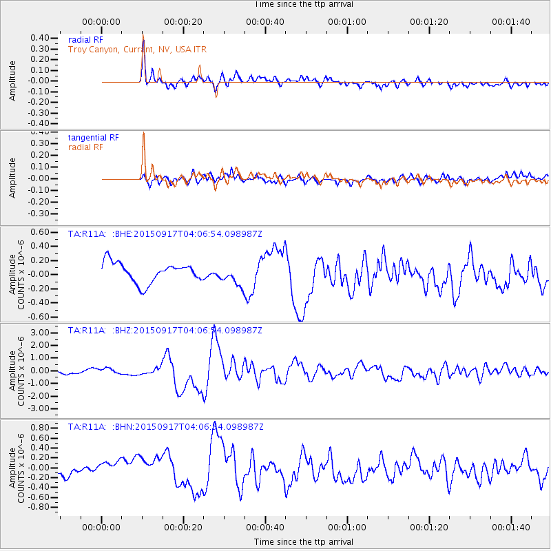
R11A Troy Canyon, Currant, NV, USA - Earthquake Result Viewer
*The percent match for this event was below the threshold and hence no stack was calculated.
| Earthquake location: |
Near Coast Of Central Chile |
| Earthquake latitude/longitude: |
-31.0/-71.4 |
| Earthquake time(UTC): |
2015/09/17 (260) 03:55:07 GMT |
| Earthquake Depth: |
35 km |
| Earthquake Magnitude: |
6.2 MO |
| Earthquake Catalog/Contributor: |
NEIC PDE/NEIC ALERT |
|
| Network: |
TA USArray Transportable Network (new EarthScope stations) |
| Station: |
R11A Troy Canyon, Currant, NV, USA |
| Lat/Lon: |
38.35 N/115.59 W |
| Elevation: |
1756 m |
|
| Distance: |
80.4 deg |
| Az: |
326.202 deg |
| Baz: |
142.578 deg |
| Ray Param: |
$rayparam |
*The percent match for this event was below the threshold and hence was not used in the summary stack. |
|
| Radial Match: |
77.51068 % |
| Radial Bump: |
400 |
| Transverse Match: |
63.173912 % |
| Transverse Bump: |
400 |
| SOD ConfigId: |
7422571 |
| Insert Time: |
2019-04-20 20:44:40.305 +0000 |
| GWidth: |
2.5 |
| Max Bumps: |
400 |
| Tol: |
0.001 |
|
Signal To Noise
| Channel | StoN | STA | LTA |
| TA:R11A: :BHZ:20150917T04:06:54.098987Z | 0.8972588 | 1.8382192E-7 | 2.0487057E-7 |
| TA:R11A: :BHN:20150917T04:06:54.098987Z | 2.4760697 | 3.217215E-7 | 1.2993233E-7 |
| TA:R11A: :BHE:20150917T04:06:54.098987Z | 0.43249533 | 7.482142E-8 | 1.7299938E-7 |
| Arrivals |
| Ps | |
| PpPs | |
| PsPs/PpSs | |


