You are here: Home > Network List > CI - Caltech Regional Seismic Network Stations List
> Station GSC Goldstone, Goldstone Lake, CA, USA > Earthquake Result Viewer
GSC Goldstone, Goldstone Lake, CA, USA - Earthquake Result Viewer
| Earthquake location: |
Kermadec Islands Region |
| Earthquake latitude/longitude: |
-28.7/-177.6 |
| Earthquake time(UTC): |
1997/09/20 (263) 16:11:32 GMT |
| Earthquake Depth: |
30 km |
| Earthquake Magnitude: |
6.1 MB, 7.0 MS, 7.2 UNKNOWN, 6.7 ME |
| Earthquake Catalog/Contributor: |
WHDF/NEIC |
|
| Network: |
CI Caltech Regional Seismic Network |
| Station: |
GSC Goldstone, Goldstone Lake, CA, USA |
| Lat/Lon: |
35.30 N/116.81 W |
| Elevation: |
1000 m |
|
| Distance: |
85.7 deg |
| Az: |
45.74 deg |
| Baz: |
230.294 deg |
| Ray Param: |
0.044569906 |
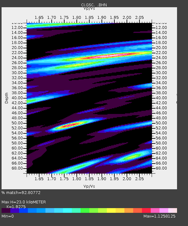
| Estimated Moho Depth: |
23.0 km |
| Estimated Crust Vp/Vs: |
1.93 |
| Assumed Crust Vp: |
6.276 km/s |
| Estimated Crust Vs: |
3.256 km/s |
| Estimated Crust Poisson's Ratio: |
0.32 |
|
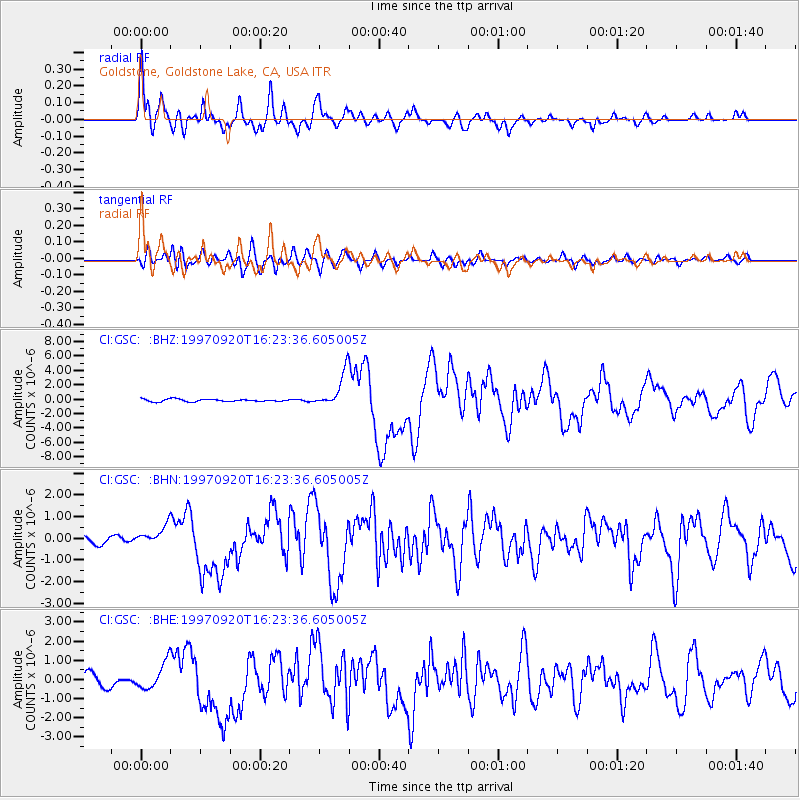
| Radial Match: |
92.80772 % |
| Radial Bump: |
400 |
| Transverse Match: |
76.5535 % |
| Transverse Bump: |
400 |
| SOD ConfigId: |
9875 |
| Insert Time: |
2010-02-25 23:45:16.705 +0000 |
| GWidth: |
2.5 |
| Max Bumps: |
400 |
| Tol: |
0.001 |
|
Signal To Noise
| Channel | StoN | STA | LTA |
| CI:GSC: :BHN:19970920T16:23:36.605005Z | 1.981625 | 4.6112996E-7 | 2.3270294E-7 |
| CI:GSC: :BHE:19970920T16:23:36.605005Z | 2.3317676 | 7.070436E-7 | 3.0322218E-7 |
| CI:GSC: :BHZ:19970920T16:23:36.605005Z | 14.471133 | 2.3968453E-6 | 1.6562942E-7 |
| Arrivals |
| Ps | 3.5 SECOND |
| PpPs | 11 SECOND |
| PsPs/PpSs | 14 SECOND |


