You are here: Home > Network List > US - United States National Seismic Network Stations List
> Station WMOK Wichita Mountains, Oklahoma, USA > Earthquake Result Viewer
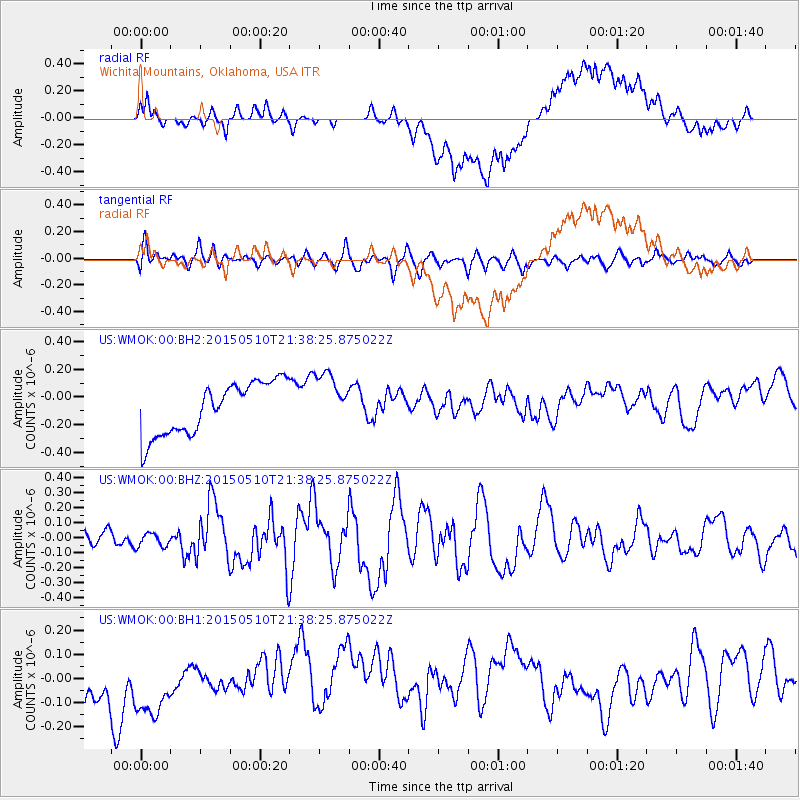
WMOK Wichita Mountains, Oklahoma, USA - Earthquake Result Viewer
*The percent match for this event was below the threshold and hence no stack was calculated.
| Earthquake location: |
Southeast Of Honshu, Japan |
| Earthquake latitude/longitude: |
31.2/142.4 |
| Earthquake time(UTC): |
2015/05/10 (130) 21:25:46 GMT |
| Earthquake Depth: |
18 km |
| Earthquake Magnitude: |
5.6 MB |
| Earthquake Catalog/Contributor: |
NEIC PDE/NEIC COMCAT |
|
| Network: |
US United States National Seismic Network |
| Station: |
WMOK Wichita Mountains, Oklahoma, USA |
| Lat/Lon: |
34.74 N/98.78 W |
| Elevation: |
486 m |
|
| Distance: |
92.7 deg |
| Az: |
46.236 deg |
| Baz: |
311.317 deg |
| Ray Param: |
$rayparam |
*The percent match for this event was below the threshold and hence was not used in the summary stack. |
|
| Radial Match: |
48.621304 % |
| Radial Bump: |
400 |
| Transverse Match: |
57.343307 % |
| Transverse Bump: |
400 |
| SOD ConfigId: |
976571 |
| Insert Time: |
2015-05-24 22:00:00.641 +0000 |
| GWidth: |
2.5 |
| Max Bumps: |
400 |
| Tol: |
0.001 |
|
Signal To Noise
| Channel | StoN | STA | LTA |
| US:WMOK:00:BHZ:20150510T21:38:25.875022Z | 0.6042807 | 4.467294E-8 | 7.392747E-8 |
| US:WMOK:00:BH1:20150510T21:38:25.875022Z | 1.1188364 | 1.9422689E-7 | 1.7359721E-7 |
| US:WMOK:00:BH2:20150510T21:38:25.875022Z | 1.0479082 | 1.969692E-7 | 1.8796418E-7 |
| Arrivals |
| Ps | |
| PpPs | |
| PsPs/PpSs | |


