You are here: Home > Network List > IU - Global Seismograph Network (GSN - IRIS/USGS) Stations List
> Station ANMO Albuquerque, New Mexico, USA > Earthquake Result Viewer
ANMO Albuquerque, New Mexico, USA - Earthquake Result Viewer
| Earthquake location: |
Southern Peru |
| Earthquake latitude/longitude: |
-16.5/-70.7 |
| Earthquake time(UTC): |
1991/05/24 (144) 20:50:55 GMT |
| Earthquake Depth: |
125 km |
| Earthquake Magnitude: |
6.3 MB, 6.8 UNKNOWN |
| Earthquake Catalog/Contributor: |
WHDF/NEIC |
|
| Network: |
IU Global Seismograph Network (GSN - IRIS/USGS) |
| Station: |
ANMO Albuquerque, New Mexico, USA |
| Lat/Lon: |
34.95 N/106.46 W |
| Elevation: |
1840 m |
|
| Distance: |
61.4 deg |
| Az: |
326.866 deg |
| Baz: |
140.33 deg |
| Ray Param: |
0.06055454 |
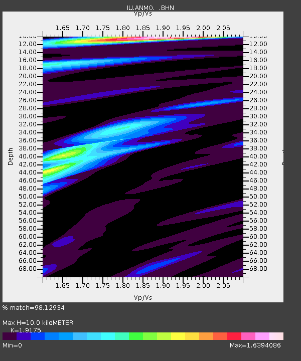
| Estimated Moho Depth: |
10.0 km |
| Estimated Crust Vp/Vs: |
1.92 |
| Assumed Crust Vp: |
6.502 km/s |
| Estimated Crust Vs: |
3.391 km/s |
| Estimated Crust Poisson's Ratio: |
0.31 |
|
| Radial Match: |
98.12934 % |
| Radial Bump: |
295 |
| Transverse Match: |
91.9757 % |
| Transverse Bump: |
400 |
| SOD ConfigId: |
17000 |
| Insert Time: |
2010-03-04 19:51:42.747 +0000 |
| GWidth: |
2.5 |
| Max Bumps: |
400 |
| Tol: |
0.001 |
|

Signal To Noise
| Channel | StoN | STA | LTA |
| IU:ANMO: :BHN:19910524T21:00:27.480017Z | 24.478174 | 2.1919202E-6 | 8.95459E-8 |
| IU:ANMO: :BHE:19910524T21:00:27.480017Z | 21.56948 | 1.8612749E-6 | 8.629206E-8 |
| IU:ANMO: :BHZ:19910524T21:00:27.480017Z | 60.674652 | 6.2339345E-6 | 1.02743634E-7 |
| Arrivals |
| Ps | 1.5 SECOND |
| PpPs | 4.3 SECOND |
| PsPs/PpSs | 5.8 SECOND |


