You are here: Home > Network List > IU - Global Seismograph Network (GSN - IRIS/USGS) Stations List
> Station ANMO Albuquerque, New Mexico, USA > Earthquake Result Viewer
ANMO Albuquerque, New Mexico, USA - Earthquake Result Viewer
| Earthquake location: |
Vanuatu Islands |
| Earthquake latitude/longitude: |
-13.6/167.6 |
| Earthquake time(UTC): |
1991/08/14 (226) 19:15:06 GMT |
| Earthquake Depth: |
33 km |
| Earthquake Magnitude: |
6.0 MB, 6.6 MS |
| Earthquake Catalog/Contributor: |
WHDF/NEIC |
|
| Network: |
IU Global Seismograph Network (GSN - IRIS/USGS) |
| Station: |
ANMO Albuquerque, New Mexico, USA |
| Lat/Lon: |
34.95 N/106.46 W |
| Elevation: |
1840 m |
|
| Distance: |
94.4 deg |
| Az: |
55.263 deg |
| Baz: |
256.57 deg |
| Ray Param: |
0.04104698 |
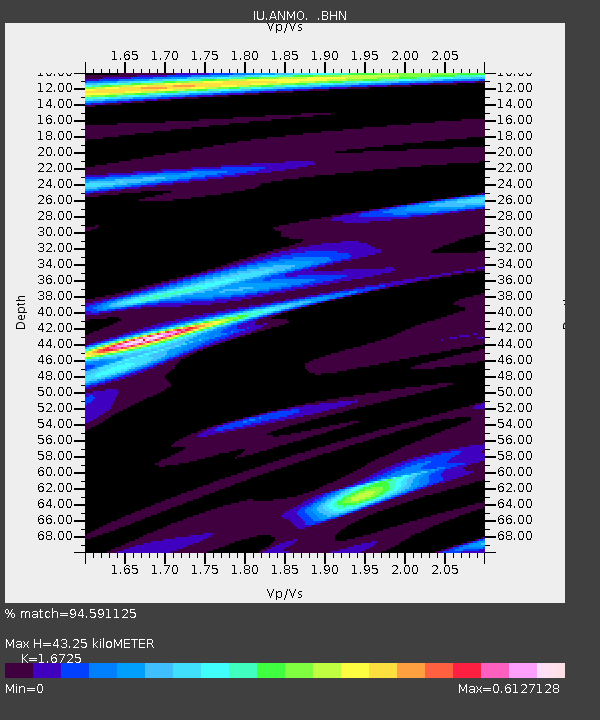
| Estimated Moho Depth: |
43.25 km |
| Estimated Crust Vp/Vs: |
1.67 |
| Assumed Crust Vp: |
6.502 km/s |
| Estimated Crust Vs: |
3.887 km/s |
| Estimated Crust Poisson's Ratio: |
0.22 |
|
| Radial Match: |
94.591125 % |
| Radial Bump: |
347 |
| Transverse Match: |
83.04986 % |
| Transverse Bump: |
400 |
| SOD ConfigId: |
17000 |
| Insert Time: |
2010-03-04 19:52:02.693 +0000 |
| GWidth: |
2.5 |
| Max Bumps: |
400 |
| Tol: |
0.001 |
|

Signal To Noise
| Channel | StoN | STA | LTA |
| IU:ANMO: :BHN:19910814T19:27:51.381018Z | 0.9098032 | 3.2687065E-8 | 3.592762E-8 |
| IU:ANMO: :BHE:19910814T19:27:51.381018Z | 1.619164 | 5.5247106E-8 | 3.412076E-8 |
| IU:ANMO: :BHZ:19910814T19:27:51.381018Z | 6.013389 | 2.3866355E-7 | 3.968869E-8 |
| Arrivals |
| Ps | 4.6 SECOND |
| PpPs | 17 SECOND |
| PsPs/PpSs | 22 SECOND |


