You are here: Home > Network List > CI - Caltech Regional Seismic Network Stations List
> Station GSC Goldstone, California, USA > Earthquake Result Viewer
GSC Goldstone, California, USA - Earthquake Result Viewer
| Earthquake location: |
Near Coast Of Central Chile |
| Earthquake latitude/longitude: |
-32.3/-71.3 |
| Earthquake time(UTC): |
1998/07/29 (210) 07:14:24 GMT |
| Earthquake Depth: |
51 km |
| Earthquake Magnitude: |
6.3 MB, 6.5 UNKNOWN, 6.5 ME |
| Earthquake Catalog/Contributor: |
WHDF/NEIC |
|
| Network: |
CI Caltech Regional Seismic Network |
| Station: |
GSC Goldstone, California, USA |
| Lat/Lon: |
35.30 N/116.81 W |
| Elevation: |
954 m |
|
| Distance: |
79.7 deg |
| Az: |
323.615 deg |
| Baz: |
142.113 deg |
| Ray Param: |
0.04870696 |
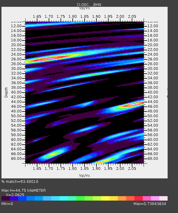
| Estimated Moho Depth: |
44.75 km |
| Estimated Crust Vp/Vs: |
2.06 |
| Assumed Crust Vp: |
6.276 km/s |
| Estimated Crust Vs: |
3.043 km/s |
| Estimated Crust Poisson's Ratio: |
0.35 |
|
| Radial Match: |
93.48018 % |
| Radial Bump: |
400 |
| Transverse Match: |
88.11758 % |
| Transverse Bump: |
400 |
| SOD ConfigId: |
4770 |
| Insert Time: |
2010-02-25 23:45:20.397 +0000 |
| GWidth: |
2.5 |
| Max Bumps: |
400 |
| Tol: |
0.001 |
|
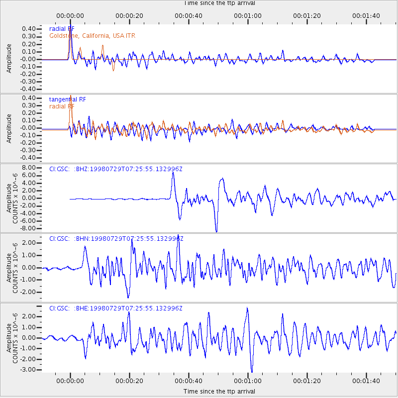
Signal To Noise
| Channel | StoN | STA | LTA |
| CI:GSC: :BHN:19980729T07:25:55.132996Z | 5.8529043 | 4.4932773E-7 | 7.677004E-8 |
| CI:GSC: :BHE:19980729T07:25:55.132996Z | 2.7296915 | 3.2927852E-7 | 1.2062847E-7 |
| CI:GSC: :BHZ:19980729T07:25:55.132996Z | 23.800821 | 2.0478199E-6 | 8.6039876E-8 |
| Arrivals |
| Ps | 7.8 SECOND |
| PpPs | 21 SECOND |
| PsPs/PpSs | 29 SECOND |


