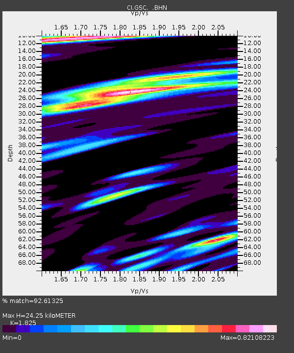
GSC Goldstone, California, USA - Earthquake Result Viewer
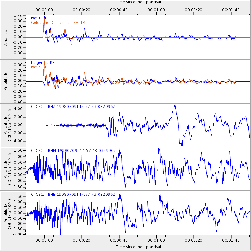
Earthquake location: Kermadec Islands, New Zealand
Earthquake latitude/longitude: -30.5/-179.0
Earthquake time(UTC): 1998/07/09 (190) 14:45:39 GMT
Earthquake Depth: 130 km
Earthquake Magnitude: 6.2 MB, 6.2 MS, 6.9 UNKNOWN, 6.4 ME
Earthquake Catalog/Contributor: WHDF/NEIC
Network: CI Caltech Regional Seismic Network
Station: GSC Goldstone, California, USA
Lat/Lon: 35.30 N/116.81 W
Elevation: 954 m
Distance: 87.8 deg
Az: 46.387 deg
Baz: 229.827 deg
Ray Param: 0.04280133
Estimated Moho Depth: 24.25 km
Estimated Crust Vp/Vs: 1.83
Assumed Crust Vp: 6.276 km/s
Estimated Crust Vs: 3.439 km/s
Estimated Crust Poisson's Ratio: 0.29
Radial Match: 92.61325 %
Radial Bump: 400
Transverse Match: 83.03931 %
Transverse Bump: 400
SOD ConfigId: 4770
Insert Time: 2010-02-25 23:45:21.459 +0000
GWidth: 2.5
Max Bumps: 400
Tol: 0.001

Signal To Noise

ChannelStoNSTALTA
CI:GSC: :BHN:19980709T14:57:43.032996Z2.69046044.4003676E-71.6355445E-7
CI:GSC: :BHE:19980709T14:57:43.032996Z3.28019125.04331E-71.5375049E-7
CI:GSC: :BHZ:19980709T14:57:43.032996Z5.9868587.6999805E-71.2861472E-7
Arrivals
Ps3.3 SECOND
PpPs11 SECOND
PsPs/PpSs14 SECOND