You are here: Home > Network List > TA - USArray Transportable Network (new EarthScope stations) Stations List
> Station X43A Marvell, AR, USA > Earthquake Result Viewer
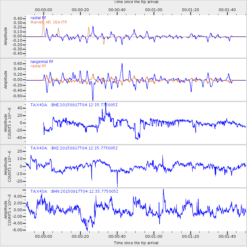
X43A Marvell, AR, USA - Earthquake Result Viewer
*The percent match for this event was below the threshold and hence no stack was calculated.
| Earthquake location: |
Near Coast Of Central Chile |
| Earthquake latitude/longitude: |
-31.2/-71.9 |
| Earthquake time(UTC): |
2015/09/17 (260) 04:02:10 GMT |
| Earthquake Depth: |
16 km |
| Earthquake Magnitude: |
5.7 mwr |
| Earthquake Catalog/Contributor: |
NEIC PDE/us |
|
| Network: |
TA USArray Transportable Network (new EarthScope stations) |
| Station: |
X43A Marvell, AR, USA |
| Lat/Lon: |
34.52 N/90.88 W |
| Elevation: |
53 m |
|
| Distance: |
67.8 deg |
| Az: |
343.159 deg |
| Baz: |
162.508 deg |
| Ray Param: |
$rayparam |
*The percent match for this event was below the threshold and hence was not used in the summary stack. |
|
| Radial Match: |
76.36151 % |
| Radial Bump: |
400 |
| Transverse Match: |
68.19229 % |
| Transverse Bump: |
400 |
| SOD ConfigId: |
7422571 |
| Insert Time: |
2019-04-20 20:53:39.972 +0000 |
| GWidth: |
2.5 |
| Max Bumps: |
400 |
| Tol: |
0.001 |
|
Signal To Noise
| Channel | StoN | STA | LTA |
| TA:X43A: :BHZ:20150917T04:12:35.775005Z | 0.52117205 | 6.58178E-6 | 1.2628804E-5 |
| TA:X43A: :BHN:20150917T04:12:35.775005Z | 1.4033496 | 2.4043995E-6 | 1.713329E-6 |
| TA:X43A: :BHE:20150917T04:12:35.775005Z | 2.4145837 | 2.2818862E-5 | 9.450433E-6 |
| Arrivals |
| Ps | |
| PpPs | |
| PsPs/PpSs | |


