You are here: Home > Network List > IU - Global Seismograph Network (GSN - IRIS/USGS) Stations List
> Station ANMO Albuquerque, New Mexico, USA > Earthquake Result Viewer
ANMO Albuquerque, New Mexico, USA - Earthquake Result Viewer

| Earthquake location: |
Southern Peru |
| Earthquake latitude/longitude: |
-15.2/-70.3 |
| Earthquake time(UTC): |
1994/06/16 (167) 18:41:31 GMT |
| Earthquake Depth: |
225 km |
| Earthquake Magnitude: |
5.6 MB, 5.8 UNKNOWN, 6.1 MW |
| Earthquake Catalog/Contributor: |
WHDF/NEIC |
|
| Network: |
IU Global Seismograph Network (GSN - IRIS/USGS) |
| Station: |
ANMO Albuquerque, New Mexico, USA |
| Lat/Lon: |
34.95 N/106.46 W |
| Elevation: |
1840 m |
|
| Distance: |
60.5 deg |
| Az: |
326.202 deg |
| Baz: |
139.17 deg |
| Ray Param: |
0.06076106 |
| Estimated Moho Depth: |
10.0 km |
| Estimated Crust Vp/Vs: |
1.92 |
| Assumed Crust Vp: |
6.502 km/s |
| Estimated Crust Vs: |
3.391 km/s |
| Estimated Crust Poisson's Ratio: |
0.31 |
|
| Radial Match: |
93.59602 % |
| Radial Bump: |
400 |
| Transverse Match: |
70.63044 % |
| Transverse Bump: |
400 |
| SOD ConfigId: |
17000 |
| Insert Time: |
2010-03-04 19:55:02.721 +0000 |
| GWidth: |
2.5 |
| Max Bumps: |
400 |
| Tol: |
0.001 |
|
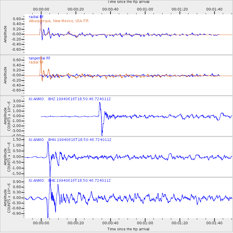
Signal To Noise
| Channel | StoN | STA | LTA |
| IU:ANMO: :BHN:19940616T18:50:46.724011Z | 9.097125 | 4.2852562E-7 | 4.7105612E-8 |
| IU:ANMO: :BHE:19940616T18:50:46.724011Z | 7.82495 | 3.626142E-7 | 4.634077E-8 |
| IU:ANMO: :BHZ:19940616T18:50:46.724011Z | 22.263601 | 9.696068E-7 | 4.355121E-8 |
| Arrivals |
| Ps | 1.5 SECOND |
| PpPs | 4.3 SECOND |
| PsPs/PpSs | 5.8 SECOND |


