You are here: Home > Network List > TA - USArray Transportable Network (new EarthScope stations) Stations List
> Station J61A Chester, VT, USA > Earthquake Result Viewer
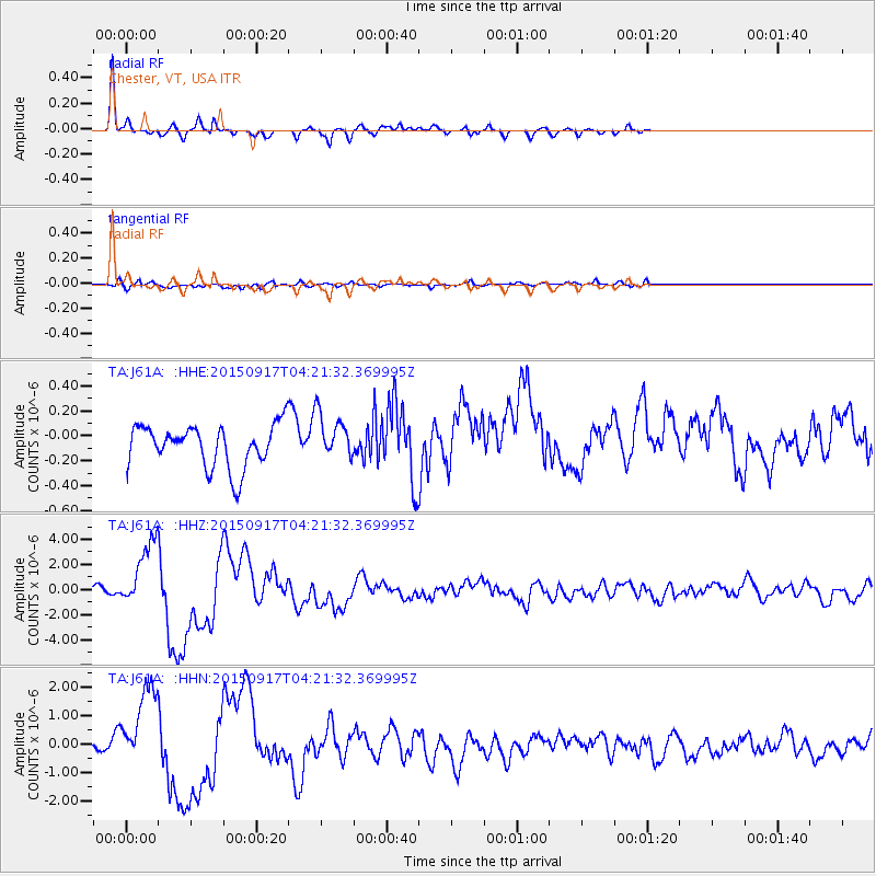
J61A Chester, VT, USA - Earthquake Result Viewer
*The percent match for this event was below the threshold and hence no stack was calculated.
| Earthquake location: |
Near Coast Of Central Chile |
| Earthquake latitude/longitude: |
-31.5/-71.8 |
| Earthquake time(UTC): |
2015/09/17 (260) 04:10:31 GMT |
| Earthquake Depth: |
40 km |
| Earthquake Magnitude: |
6.3 MB |
| Earthquake Catalog/Contributor: |
NEIC PDE/NEIC COMCAT |
|
| Network: |
TA USArray Transportable Network (new EarthScope stations) |
| Station: |
J61A Chester, VT, USA |
| Lat/Lon: |
43.35 N/72.55 W |
| Elevation: |
253 m |
|
| Distance: |
74.5 deg |
| Az: |
359.408 deg |
| Baz: |
179.307 deg |
| Ray Param: |
$rayparam |
*The percent match for this event was below the threshold and hence was not used in the summary stack. |
|
| Radial Match: |
84.16723 % |
| Radial Bump: |
262 |
| Transverse Match: |
60.85842 % |
| Transverse Bump: |
400 |
| SOD ConfigId: |
7422571 |
| Insert Time: |
2019-04-20 21:02:42.665 +0000 |
| GWidth: |
2.5 |
| Max Bumps: |
400 |
| Tol: |
0.001 |
|
Signal To Noise
| Channel | StoN | STA | LTA |
| TA:J61A: :HHZ:20150917T04:21:32.369995Z | 11.147602 | 2.7039696E-6 | 2.4256065E-7 |
| TA:J61A: :HHN:20150917T04:21:32.369995Z | 3.6383517 | 1.5062085E-6 | 4.13981E-7 |
| TA:J61A: :HHE:20150917T04:21:32.369995Z | 0.6102928 | 1.0962609E-7 | 1.796287E-7 |
| Arrivals |
| Ps | |
| PpPs | |
| PsPs/PpSs | |


