You are here: Home > Network List > TA - USArray Transportable Network (new EarthScope stations) Stations List
> Station K61A Williamstown, MA, USA > Earthquake Result Viewer
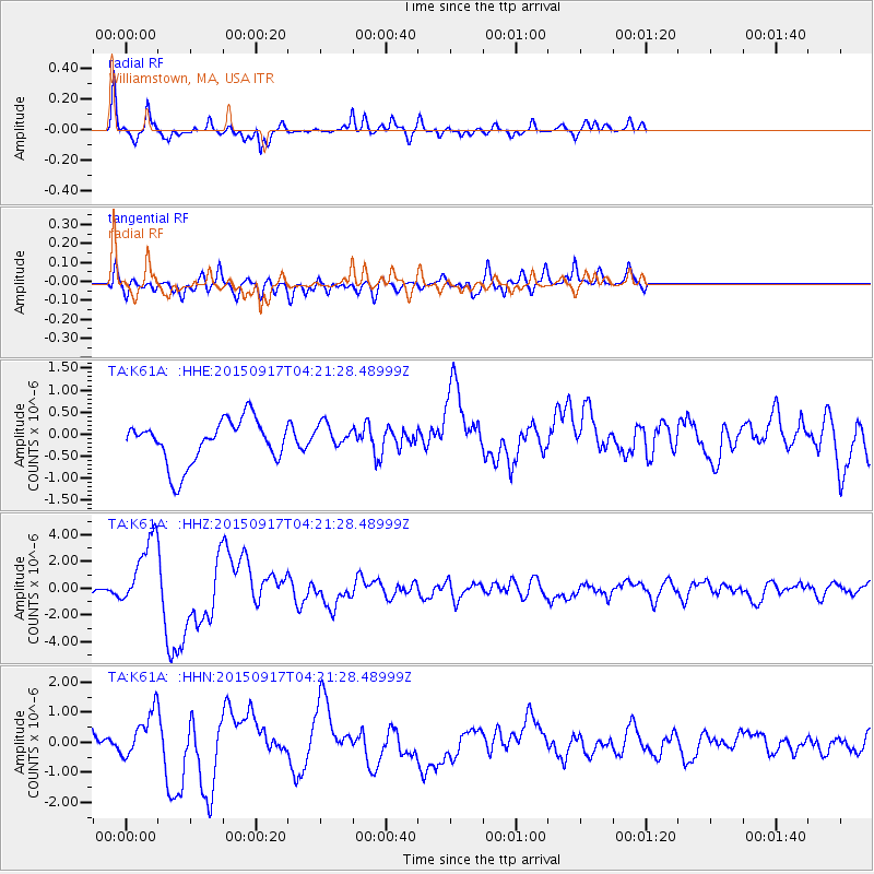
K61A Williamstown, MA, USA - Earthquake Result Viewer
*The percent match for this event was below the threshold and hence no stack was calculated.
| Earthquake location: |
Near Coast Of Central Chile |
| Earthquake latitude/longitude: |
-31.5/-71.8 |
| Earthquake time(UTC): |
2015/09/17 (260) 04:10:31 GMT |
| Earthquake Depth: |
40 km |
| Earthquake Magnitude: |
6.3 MB |
| Earthquake Catalog/Contributor: |
NEIC PDE/NEIC COMCAT |
|
| Network: |
TA USArray Transportable Network (new EarthScope stations) |
| Station: |
K61A Williamstown, MA, USA |
| Lat/Lon: |
42.67 N/73.27 W |
| Elevation: |
391 m |
|
| Distance: |
73.8 deg |
| Az: |
358.851 deg |
| Baz: |
178.67 deg |
| Ray Param: |
$rayparam |
*The percent match for this event was below the threshold and hence was not used in the summary stack. |
|
| Radial Match: |
83.15255 % |
| Radial Bump: |
261 |
| Transverse Match: |
56.893795 % |
| Transverse Bump: |
400 |
| SOD ConfigId: |
7422571 |
| Insert Time: |
2019-04-20 21:02:44.943 +0000 |
| GWidth: |
2.5 |
| Max Bumps: |
400 |
| Tol: |
0.001 |
|
Signal To Noise
| Channel | StoN | STA | LTA |
| TA:K61A: :HHZ:20150917T04:21:28.48999Z | 7.1736045 | 2.6507191E-6 | 3.6951008E-7 |
| TA:K61A: :HHN:20150917T04:21:28.48999Z | 1.5556358 | 7.7420424E-7 | 4.9767704E-7 |
| TA:K61A: :HHE:20150917T04:21:28.48999Z | 0.4087651 | 2.0454844E-7 | 5.004058E-7 |
| Arrivals |
| Ps | |
| PpPs | |
| PsPs/PpSs | |


