You are here: Home > Network List > CI - Caltech Regional Seismic Network Stations List
> Station GSC Goldstone, Goldstone Lake, CA, USA > Earthquake Result Viewer
GSC Goldstone, Goldstone Lake, CA, USA - Earthquake Result Viewer
| Earthquake location: |
Southern Peru |
| Earthquake latitude/longitude: |
-16.1/-71.4 |
| Earthquake time(UTC): |
1998/10/08 (281) 04:51:42 GMT |
| Earthquake Depth: |
136 km |
| Earthquake Magnitude: |
6.1 MB, 6.4 UNKNOWN, 6.2 MW |
| Earthquake Catalog/Contributor: |
WHDF/NEIC |
|
| Network: |
CI Caltech Regional Seismic Network |
| Station: |
GSC Goldstone, Goldstone Lake, CA, USA |
| Lat/Lon: |
35.30 N/116.81 W |
| Elevation: |
1000 m |
|
| Distance: |
66.8 deg |
| Az: |
320.694 deg |
| Baz: |
131.893 deg |
| Ray Param: |
0.056974147 |
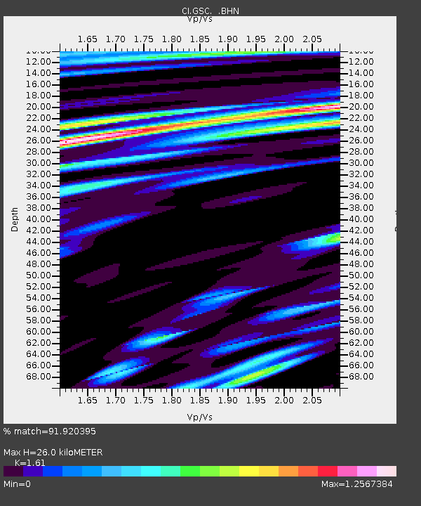
| Estimated Moho Depth: |
26.0 km |
| Estimated Crust Vp/Vs: |
1.61 |
| Assumed Crust Vp: |
6.276 km/s |
| Estimated Crust Vs: |
3.898 km/s |
| Estimated Crust Poisson's Ratio: |
0.19 |
|
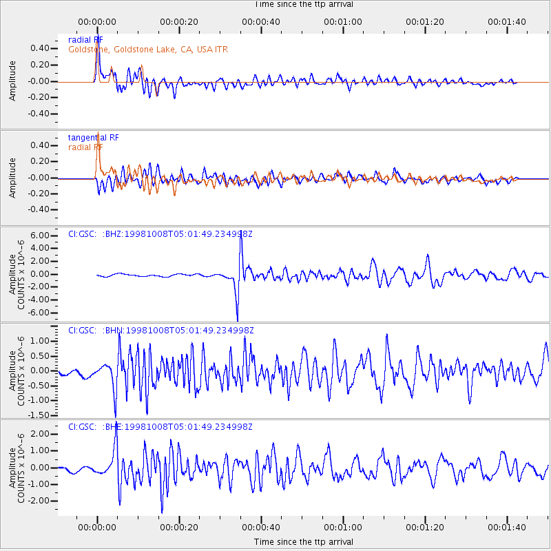
| Radial Match: |
91.920395 % |
| Radial Bump: |
400 |
| Transverse Match: |
87.20153 % |
| Transverse Bump: |
400 |
| SOD ConfigId: |
3787 |
| Insert Time: |
2010-02-25 23:45:37.757 +0000 |
| GWidth: |
2.5 |
| Max Bumps: |
400 |
| Tol: |
0.001 |
|
Signal To Noise
| Channel | StoN | STA | LTA |
| CI:GSC: :BHN:19981008T05:01:49.234998Z | 2.4130309 | 4.536267E-7 | 1.8799042E-7 |
| CI:GSC: :BHE:19981008T05:01:49.234998Z | 6.559234 | 9.015862E-7 | 1.3745297E-7 |
| CI:GSC: :BHZ:19981008T05:01:49.234998Z | 12.035338 | 2.1065223E-6 | 1.7502809E-7 |
| Arrivals |
| Ps | 2.6 SECOND |
| PpPs | 10 SECOND |
| PsPs/PpSs | 13 SECOND |


