You are here: Home > Network List > CI - Caltech Regional Seismic Network Stations List
> Station GSC Goldstone, Goldstone Lake, CA, USA > Earthquake Result Viewer
GSC Goldstone, Goldstone Lake, CA, USA - Earthquake Result Viewer
| Earthquake location: |
Santa Cruz Islands |
| Earthquake latitude/longitude: |
-11.0/166.2 |
| Earthquake time(UTC): |
1998/07/16 (197) 11:56:36 GMT |
| Earthquake Depth: |
110 km |
| Earthquake Magnitude: |
6.4 MB, 6.7 MS, 7.1 UNKNOWN, 6.9 ME |
| Earthquake Catalog/Contributor: |
WHDF/NEIC |
|
| Network: |
CI Caltech Regional Seismic Network |
| Station: |
GSC Goldstone, Goldstone Lake, CA, USA |
| Lat/Lon: |
35.30 N/116.81 W |
| Elevation: |
1000 m |
|
| Distance: |
85.9 deg |
| Az: |
53.043 deg |
| Baz: |
253.558 deg |
| Ray Param: |
0.044169396 |
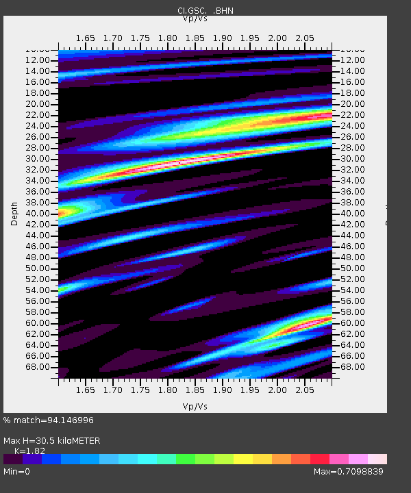
| Estimated Moho Depth: |
30.5 km |
| Estimated Crust Vp/Vs: |
1.82 |
| Assumed Crust Vp: |
6.276 km/s |
| Estimated Crust Vs: |
3.448 km/s |
| Estimated Crust Poisson's Ratio: |
0.28 |
|
| Radial Match: |
94.146996 % |
| Radial Bump: |
400 |
| Transverse Match: |
87.81883 % |
| Transverse Bump: |
400 |
| SOD ConfigId: |
9875 |
| Insert Time: |
2010-02-25 23:45:41.695 +0000 |
| GWidth: |
2.5 |
| Max Bumps: |
400 |
| Tol: |
0.001 |
|
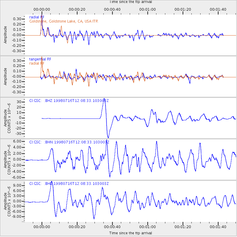
Signal To Noise
| Channel | StoN | STA | LTA |
| CI:GSC: :BHN:19980716T12:08:33.103003Z | 7.8808665 | 7.548481E-7 | 9.578237E-8 |
| CI:GSC: :BHE:19980716T12:08:33.103003Z | 23.36417 | 2.294547E-6 | 9.8207934E-8 |
| CI:GSC: :BHZ:19980716T12:08:33.103003Z | 62.452988 | 8.959741E-6 | 1.4346375E-7 |
| Arrivals |
| Ps | 4.1 SECOND |
| PpPs | 13 SECOND |
| PsPs/PpSs | 17 SECOND |


