You are here: Home > Network List > IU - Global Seismograph Network (GSN - IRIS/USGS) Stations List
> Station PMG Port Moresby, New Guinea > Earthquake Result Viewer
PMG Port Moresby, New Guinea - Earthquake Result Viewer
| Earthquake location: |
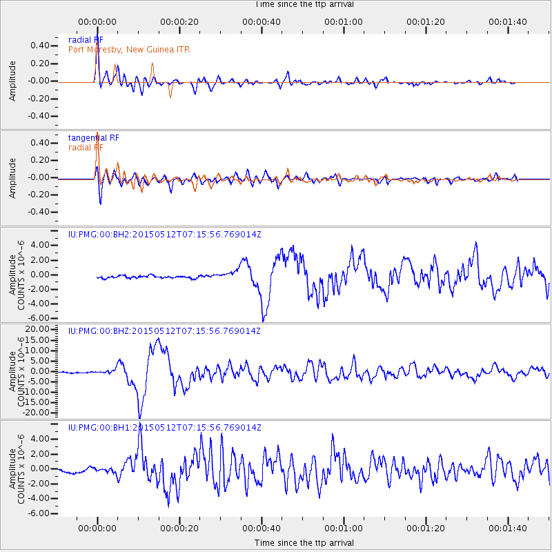
Nepal |
| Earthquake latitude/longitude: |
27.8/86.1 |
| Earthquake time(UTC): |
2015/05/12 (132) 07:05:19 GMT |
| Earthquake Depth: |
15 km |
| Earthquake Magnitude: |
7.3 MWW |
| Earthquake Catalog/Contributor: |
NEIC PDE/NEIC COMCAT |
|
| Network: |
IU Global Seismograph Network (GSN - IRIS/USGS) |
| Station: |
PMG Port Moresby, New Guinea |
| Lat/Lon: |
9.40 S/147.16 E |
| Elevation: |
90 m |
|
| Distance: |
69.7 deg |
| Az: |
112.931 deg |
| Baz: |
304.254 deg |
| Ray Param: |
0.05547072 |
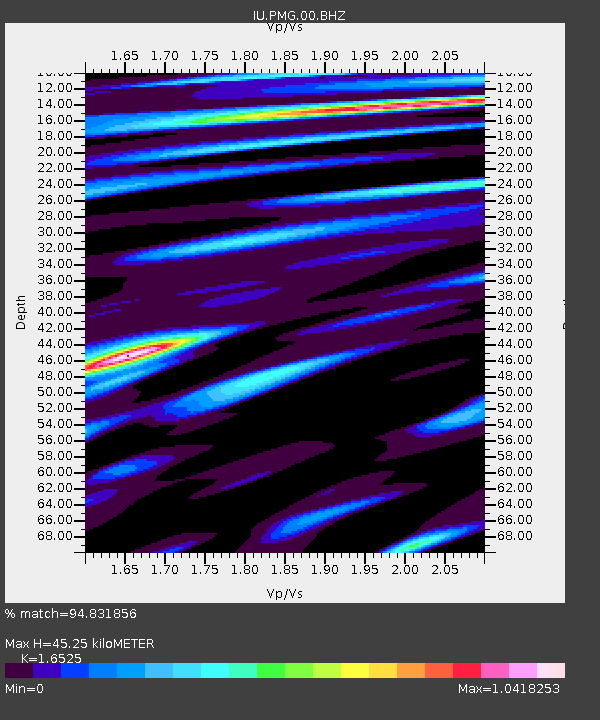
| Estimated Moho Depth: |
45.25 km |
| Estimated Crust Vp/Vs: |
1.65 |
| Assumed Crust Vp: |
6.122 km/s |
| Estimated Crust Vs: |
3.705 km/s |
| Estimated Crust Poisson's Ratio: |
0.21 |
|
| Radial Match: |
94.831856 % |
| Radial Bump: |
400 |
| Transverse Match: |
86.28542 % |
| Transverse Bump: |
400 |
| SOD ConfigId: |
976571 |
| Insert Time: |
2015-05-26 07:22:59.811 +0000 |
| GWidth: |
2.5 |
| Max Bumps: |
400 |
| Tol: |
0.001 |
|
Signal To Noise
| Channel | StoN | STA | LTA |
| IU:PMG:00:BHZ:20150512T07:15:56.769014Z | 4.0878625 | 1.1707317E-6 | 2.8639215E-7 |
| IU:PMG:00:BH1:20150512T07:15:56.769014Z | 1.383776 | 3.1051005E-7 | 2.2439329E-7 |
| IU:PMG:00:BH2:20150512T07:15:56.769014Z | 4.3145523 | 6.983837E-7 | 1.61867E-7 |
| Arrivals |
| Ps | 5.0 SECOND |
| PpPs | 19 SECOND |
| PsPs/PpSs | 24 SECOND |


