You are here: Home > Network List > TA - USArray Transportable Network (new EarthScope stations) Stations List
> Station J04D Umpqua National Forest, Toketee, OR, USA > Earthquake Result Viewer
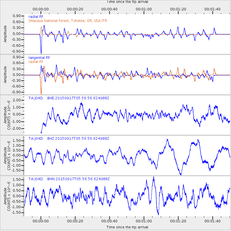
J04D Umpqua National Forest, Toketee, OR, USA - Earthquake Result Viewer
*The percent match for this event was below the threshold and hence no stack was calculated.
| Earthquake location: |
Off Coast Of Central Chile |
| Earthquake latitude/longitude: |
-31.8/-72.2 |
| Earthquake time(UTC): |
2015/09/17 (260) 05:44:39 GMT |
| Earthquake Depth: |
10 km |
| Earthquake Magnitude: |
5.5 MO |
| Earthquake Catalog/Contributor: |
NEIC PDE/NEIC ALERT |
|
| Network: |
TA USArray Transportable Network (new EarthScope stations) |
| Station: |
J04D Umpqua National Forest, Toketee, OR, USA |
| Lat/Lon: |
43.24 N/122.11 W |
| Elevation: |
1948 m |
|
| Distance: |
87.6 deg |
| Az: |
325.959 deg |
| Baz: |
139.295 deg |
| Ray Param: |
$rayparam |
*The percent match for this event was below the threshold and hence was not used in the summary stack. |
|
| Radial Match: |
58.350113 % |
| Radial Bump: |
400 |
| Transverse Match: |
55.04068 % |
| Transverse Bump: |
400 |
| SOD ConfigId: |
7422571 |
| Insert Time: |
2019-04-20 21:16:34.787 +0000 |
| GWidth: |
2.5 |
| Max Bumps: |
400 |
| Tol: |
0.001 |
|
Signal To Noise
| Channel | StoN | STA | LTA |
| TA:J04D: :BHZ:20150917T05:56:56.624988Z | 1.2504091 | 4.618465E-7 | 3.693563E-7 |
| TA:J04D: :BHN:20150917T05:56:56.624988Z | 1.0081003 | 4.5324862E-7 | 4.4960666E-7 |
| TA:J04D: :BHE:20150917T05:56:56.624988Z | 0.6760631 | 6.1690804E-7 | 9.1250064E-7 |
| Arrivals |
| Ps | |
| PpPs | |
| PsPs/PpSs | |


