You are here: Home > Network List > TA - USArray Transportable Network (new EarthScope stations) Stations List
> Station O48A Farmland, IN, USA > Earthquake Result Viewer
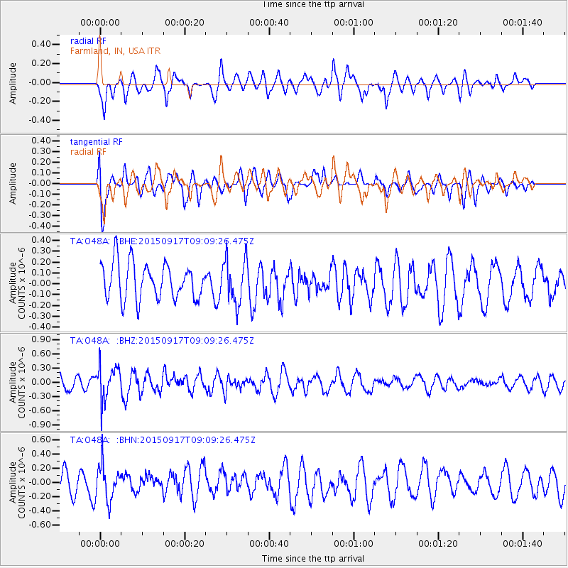
O48A Farmland, IN, USA - Earthquake Result Viewer
*The percent match for this event was below the threshold and hence no stack was calculated.
| Earthquake location: |
Near East Coast Of Kamchatka |
| Earthquake latitude/longitude: |
53.3/159.7 |
| Earthquake time(UTC): |
2015/09/17 (260) 08:58:44 GMT |
| Earthquake Depth: |
69 km |
| Earthquake Magnitude: |
5.5 MB |
| Earthquake Catalog/Contributor: |
NEIC PDE/NEIC COMCAT |
|
| Network: |
TA USArray Transportable Network (new EarthScope stations) |
| Station: |
O48A Farmland, IN, USA |
| Lat/Lon: |
40.26 N/85.16 W |
| Elevation: |
300 m |
|
| Distance: |
71.4 deg |
| Az: |
46.988 deg |
| Baz: |
325.004 deg |
| Ray Param: |
$rayparam |
*The percent match for this event was below the threshold and hence was not used in the summary stack. |
|
| Radial Match: |
58.20062 % |
| Radial Bump: |
400 |
| Transverse Match: |
69.29405 % |
| Transverse Bump: |
400 |
| SOD ConfigId: |
7422571 |
| Insert Time: |
2019-04-20 21:25:06.620 +0000 |
| GWidth: |
2.5 |
| Max Bumps: |
400 |
| Tol: |
0.001 |
|
Signal To Noise
| Channel | StoN | STA | LTA |
| TA:O48A: :BHZ:20150917T09:09:26.475Z | 1.9072244 | 3.715043E-7 | 1.9478794E-7 |
| TA:O48A: :BHN:20150917T09:09:26.475Z | 2.1519613 | 2.5720868E-7 | 1.1952291E-7 |
| TA:O48A: :BHE:20150917T09:09:26.475Z | 1.2531345 | 2.0848972E-7 | 1.6637458E-7 |
| Arrivals |
| Ps | |
| PpPs | |
| PsPs/PpSs | |


