You are here: Home > Network List > IU - Global Seismograph Network (GSN - IRIS/USGS) Stations List
> Station RAR Rarotonga, Cook Islands > Earthquake Result Viewer
RAR Rarotonga, Cook Islands - Earthquake Result Viewer

| Earthquake location: |
Northern Peru |
| Earthquake latitude/longitude: |
-5.7/-76.4 |
| Earthquake time(UTC): |
2005/09/26 (269) 01:55:37 GMT |
| Earthquake Depth: |
115 km |
| Earthquake Magnitude: |
6.7 MB, 7.5 MW, 7.5 MW |
| Earthquake Catalog/Contributor: |
WHDF/NEIC |
|
| Network: |
IU Global Seismograph Network (GSN - IRIS/USGS) |
| Station: |
RAR Rarotonga, Cook Islands |
| Lat/Lon: |
21.21 S/159.77 W |
| Elevation: |
28 m |
|
| Distance: |
81.8 deg |
| Az: |
249.453 deg |
| Baz: |
92.919 deg |
| Ray Param: |
0.047065914 |
| Estimated Moho Depth: |
61.0 km |
| Estimated Crust Vp/Vs: |
1.87 |
| Assumed Crust Vp: |
4.24 km/s |
| Estimated Crust Vs: |
2.267 km/s |
| Estimated Crust Poisson's Ratio: |
0.30 |
|
| Radial Match: |
91.66747 % |
| Radial Bump: |
400 |
| Transverse Match: |
62.561245 % |
| Transverse Bump: |
400 |
| SOD ConfigId: |
2475 |
| Insert Time: |
2010-03-04 20:02:47.838 +0000 |
| GWidth: |
2.5 |
| Max Bumps: |
400 |
| Tol: |
0.001 |
|
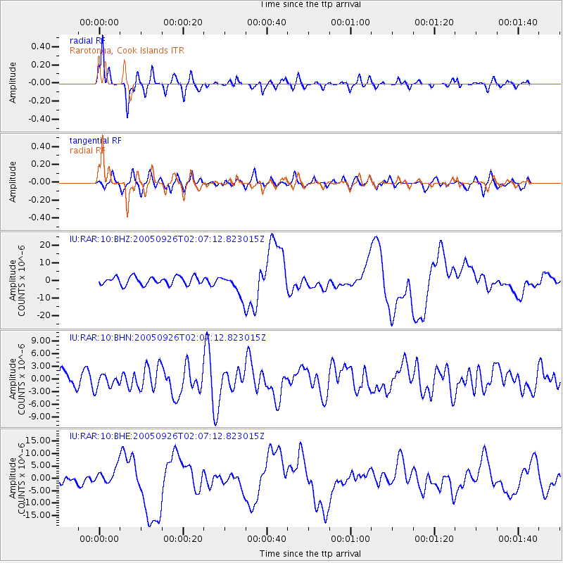
Signal To Noise
| Channel | StoN | STA | LTA |
| IU:RAR:10:BHN:20050926T02:07:12.823015Z | 0.49698836 | 1.4504934E-6 | 2.9185662E-6 |
| IU:RAR:10:BHE:20050926T02:07:12.823015Z | 1.6851948 | 3.4315963E-6 | 2.0363202E-6 |
| IU:RAR:10:BHZ:20050926T02:07:12.823015Z | 3.0097277 | 6.918608E-6 | 2.2987488E-6 |
| Arrivals |
| Ps | 13 SECOND |
| PpPs | 41 SECOND |
| PsPs/PpSs | 54 SECOND |


