You are here: Home > Network List > IU - Global Seismograph Network (GSN - IRIS/USGS) Stations List
> Station COR Corvallis, Oregon, USA > Earthquake Result Viewer
COR Corvallis, Oregon, USA - Earthquake Result Viewer
| Earthquake location: |
Western Honshu, Japan |
| Earthquake latitude/longitude: |
35.5/133.1 |
| Earthquake time(UTC): |
2000/10/06 (280) 04:30:19 GMT |
| Earthquake Depth: |
10 km |
| Earthquake Magnitude: |
5.8 MB, 6.8 MS, 7.0 ME, 6.7 MW |
| Earthquake Catalog/Contributor: |
WHDF/NEIC |
|
| Network: |
IU Global Seismograph Network (GSN - IRIS/USGS) |
| Station: |
COR Corvallis, Oregon, USA |
| Lat/Lon: |
44.59 N/123.30 W |
| Elevation: |
121 m |
|
| Distance: |
74.5 deg |
| Az: |
46.124 deg |
| Baz: |
304.556 deg |
| Ray Param: |
0.052290197 |
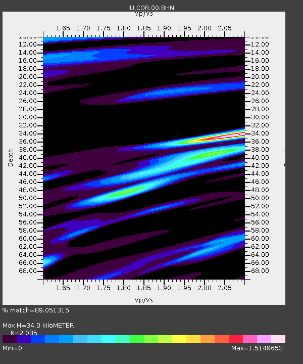
| Estimated Moho Depth: |
34.0 km |
| Estimated Crust Vp/Vs: |
2.09 |
| Assumed Crust Vp: |
6.566 km/s |
| Estimated Crust Vs: |
3.149 km/s |
| Estimated Crust Poisson's Ratio: |
0.35 |
|
| Radial Match: |
89.051315 % |
| Radial Bump: |
327 |
| Transverse Match: |
81.22205 % |
| Transverse Bump: |
400 |
| SOD ConfigId: |
3744 |
| Insert Time: |
2010-03-04 20:03:05.424 +0000 |
| GWidth: |
2.5 |
| Max Bumps: |
400 |
| Tol: |
0.001 |
|
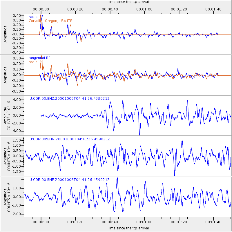
Signal To Noise
| Channel | StoN | STA | LTA |
| IU:COR:00:BHN:20001006T04:41:26.459021Z | 0.9606421 | 2.710587E-7 | 2.8216408E-7 |
| IU:COR:00:BHE:20001006T04:41:26.459021Z | 1.0505538 | 2.7053403E-7 | 2.5751564E-7 |
| IU:COR:00:BHZ:20001006T04:41:26.459021Z | 1.0444382 | 2.66838E-7 | 2.554847E-7 |
| Arrivals |
| Ps | 5.8 SECOND |
| PpPs | 16 SECOND |
| PsPs/PpSs | 21 SECOND |


