You are here: Home > Network List > IU - Global Seismograph Network (GSN - IRIS/USGS) Stations List
> Station COR Corvallis, Oregon, USA > Earthquake Result Viewer
COR Corvallis, Oregon, USA - Earthquake Result Viewer
| Earthquake location: |
Vanuatu Islands |
| Earthquake latitude/longitude: |
-15.3/167.4 |
| Earthquake time(UTC): |
1990/07/27 (208) 12:38:00 GMT |
| Earthquake Depth: |
133 km |
| Earthquake Magnitude: |
6.4 MB, 6.8 MS, 6.9 UNKNOWN |
| Earthquake Catalog/Contributor: |
WHDF/NEIC |
|
| Network: |
IU Global Seismograph Network (GSN - IRIS/USGS) |
| Station: |
COR Corvallis, Oregon, USA |
| Lat/Lon: |
44.59 N/123.30 W |
| Elevation: |
121 m |
|
| Distance: |
86.6 deg |
| Az: |
42.039 deg |
| Baz: |
244.724 deg |
| Ray Param: |
0.043668736 |
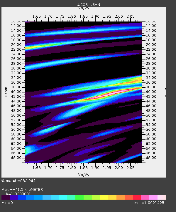
| Estimated Moho Depth: |
41.5 km |
| Estimated Crust Vp/Vs: |
1.93 |
| Assumed Crust Vp: |
6.566 km/s |
| Estimated Crust Vs: |
3.402 km/s |
| Estimated Crust Poisson's Ratio: |
0.32 |
|
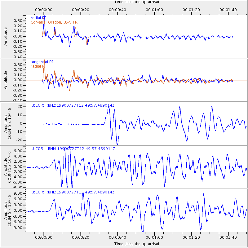
| Radial Match: |
95.1064 % |
| Radial Bump: |
275 |
| Transverse Match: |
94.11758 % |
| Transverse Bump: |
400 |
| SOD ConfigId: |
16938 |
| Insert Time: |
2010-03-04 20:03:36.049 +0000 |
| GWidth: |
2.5 |
| Max Bumps: |
400 |
| Tol: |
0.001 |
|
Signal To Noise
| Channel | StoN | STA | LTA |
| IU:COR: :BHN:19900727T12:49:57.489014Z | 3.0338914 | 6.81942E-7 | 2.2477468E-7 |
| IU:COR: :BHE:19900727T12:49:57.489014Z | 6.4260497 | 1.4066266E-6 | 2.1889444E-7 |
| IU:COR: :BHZ:19900727T12:49:57.489014Z | 17.981983 | 5.939087E-6 | 3.3027987E-7 |
| Arrivals |
| Ps | 6.0 SECOND |
| PpPs | 18 SECOND |
| PsPs/PpSs | 24 SECOND |


