You are here: Home > Network List > IU - Global Seismograph Network (GSN - IRIS/USGS) Stations List
> Station COR Corvallis, Oregon, USA > Earthquake Result Viewer
COR Corvallis, Oregon, USA - Earthquake Result Viewer
| Earthquake location: |
Southern Peru |
| Earthquake latitude/longitude: |
-16.5/-70.7 |
| Earthquake time(UTC): |
1991/05/24 (144) 20:50:55 GMT |
| Earthquake Depth: |
125 km |
| Earthquake Magnitude: |
6.3 MB, 6.8 UNKNOWN |
| Earthquake Catalog/Contributor: |
WHDF/NEIC |
|
| Network: |
IU Global Seismograph Network (GSN - IRIS/USGS) |
| Station: |
COR Corvallis, Oregon, USA |
| Lat/Lon: |
44.59 N/123.30 W |
| Elevation: |
121 m |
|
| Distance: |
77.3 deg |
| Az: |
324.43 deg |
| Baz: |
128.645 deg |
| Ray Param: |
0.05009303 |
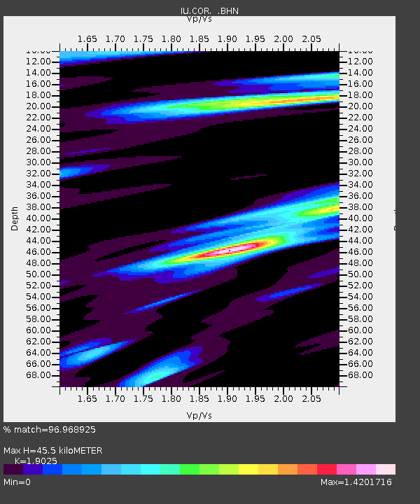
| Estimated Moho Depth: |
45.5 km |
| Estimated Crust Vp/Vs: |
1.90 |
| Assumed Crust Vp: |
6.566 km/s |
| Estimated Crust Vs: |
3.451 km/s |
| Estimated Crust Poisson's Ratio: |
0.31 |
|
| Radial Match: |
96.968925 % |
| Radial Bump: |
324 |
| Transverse Match: |
90.99143 % |
| Transverse Bump: |
400 |
| SOD ConfigId: |
16938 |
| Insert Time: |
2010-03-04 20:04:00.552 +0000 |
| GWidth: |
2.5 |
| Max Bumps: |
400 |
| Tol: |
0.001 |
|
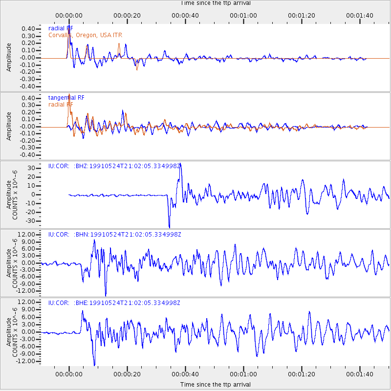
Signal To Noise
| Channel | StoN | STA | LTA |
| IU:COR: :BHN:19910524T21:02:05.334998Z | 4.7409887 | 2.0332325E-6 | 4.288625E-7 |
| IU:COR: :BHE:19910524T21:02:05.334998Z | 8.299822 | 2.6484727E-6 | 3.190999E-7 |
| IU:COR: :BHZ:19910524T21:02:05.334998Z | 18.80368 | 1.06406405E-5 | 5.658808E-7 |
| Arrivals |
| Ps | 6.4 SECOND |
| PpPs | 20 SECOND |
| PsPs/PpSs | 26 SECOND |


