You are here: Home > Network List > IU - Global Seismograph Network (GSN - IRIS/USGS) Stations List
> Station COR Corvallis, Oregon, USA > Earthquake Result Viewer
COR Corvallis, Oregon, USA - Earthquake Result Viewer
| Earthquake location: |
Fiji Islands Region |
| Earthquake latitude/longitude: |
-20.2/-176.3 |
| Earthquake time(UTC): |
1991/06/09 (160) 07:45:06 GMT |
| Earthquake Depth: |
305 km |
| Earthquake Magnitude: |
6.1 MB |
| Earthquake Catalog/Contributor: |
WHDF/NEIC |
|
| Network: |
IU Global Seismograph Network (GSN - IRIS/USGS) |
| Station: |
COR Corvallis, Oregon, USA |
| Lat/Lon: |
44.59 N/123.30 W |
| Elevation: |
121 m |
|
| Distance: |
80.6 deg |
| Az: |
35.348 deg |
| Baz: |
229.513 deg |
| Ray Param: |
0.047383 |
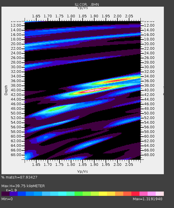
| Estimated Moho Depth: |
39.75 km |
| Estimated Crust Vp/Vs: |
1.90 |
| Assumed Crust Vp: |
6.566 km/s |
| Estimated Crust Vs: |
3.456 km/s |
| Estimated Crust Poisson's Ratio: |
0.31 |
|
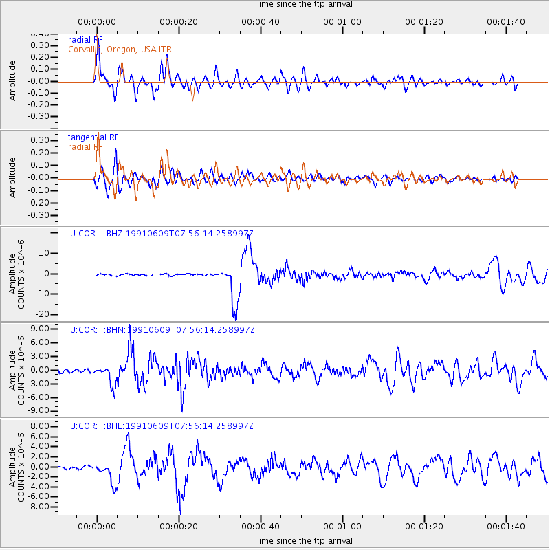
| Radial Match: |
87.93427 % |
| Radial Bump: |
400 |
| Transverse Match: |
83.39933 % |
| Transverse Bump: |
400 |
| SOD ConfigId: |
16938 |
| Insert Time: |
2010-03-04 20:04:02.941 +0000 |
| GWidth: |
2.5 |
| Max Bumps: |
400 |
| Tol: |
0.001 |
|
Signal To Noise
| Channel | StoN | STA | LTA |
| IU:COR: :BHN:19910609T07:56:14.258997Z | 7.3124375 | 2.2290153E-6 | 3.0482522E-7 |
| IU:COR: :BHE:19910609T07:56:14.258997Z | 7.5008802 | 2.236614E-6 | 2.981802E-7 |
| IU:COR: :BHZ:19910609T07:56:14.258997Z | 24.48428 | 9.954651E-6 | 4.0657318E-7 |
| Arrivals |
| Ps | 5.6 SECOND |
| PpPs | 17 SECOND |
| PsPs/PpSs | 23 SECOND |


