You are here: Home > Network List > IU - Global Seismograph Network (GSN - IRIS/USGS) Stations List
> Station COR Corvallis, Oregon, USA > Earthquake Result Viewer
COR Corvallis, Oregon, USA - Earthquake Result Viewer
| Earthquake location: |
Santiago Del Estero Prov., Arg. |
| Earthquake latitude/longitude: |
-26.8/-63.4 |
| Earthquake time(UTC): |
1991/06/23 (174) 21:22:30 GMT |
| Earthquake Depth: |
581 km |
| Earthquake Magnitude: |
6.4 MB, 6.2 UNKNOWN |
| Earthquake Catalog/Contributor: |
WHDF/NEIC |
|
| Network: |
IU Global Seismograph Network (GSN - IRIS/USGS) |
| Station: |
COR Corvallis, Oregon, USA |
| Lat/Lon: |
44.59 N/123.30 W |
| Elevation: |
121 m |
|
| Distance: |
89.6 deg |
| Az: |
321.814 deg |
| Baz: |
129.362 deg |
| Ray Param: |
0.04154471 |
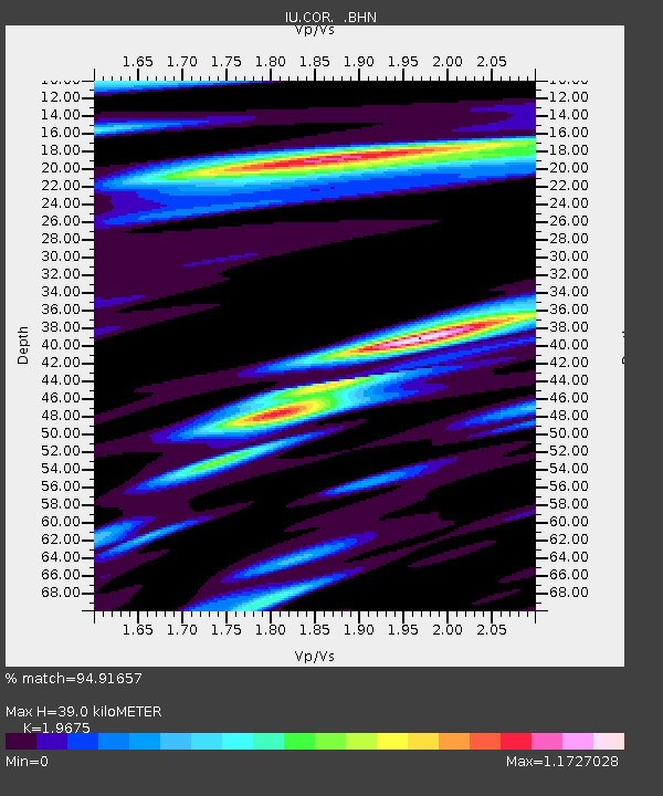
| Estimated Moho Depth: |
39.0 km |
| Estimated Crust Vp/Vs: |
1.97 |
| Assumed Crust Vp: |
6.566 km/s |
| Estimated Crust Vs: |
3.337 km/s |
| Estimated Crust Poisson's Ratio: |
0.33 |
|
| Radial Match: |
94.91657 % |
| Radial Bump: |
400 |
| Transverse Match: |
85.712616 % |
| Transverse Bump: |
400 |
| SOD ConfigId: |
16938 |
| Insert Time: |
2010-03-04 20:04:04.958 +0000 |
| GWidth: |
2.5 |
| Max Bumps: |
400 |
| Tol: |
0.001 |
|
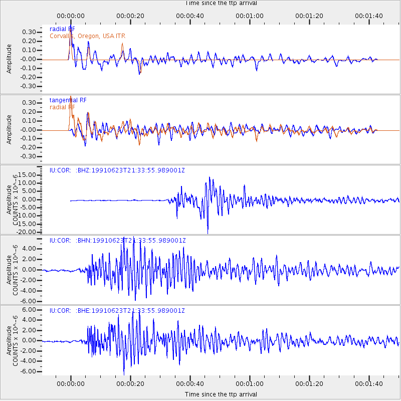
Signal To Noise
| Channel | StoN | STA | LTA |
| IU:COR: :BHN:19910623T21:33:55.989001Z | 2.026063 | 1.7624382E-7 | 8.6988315E-8 |
| IU:COR: :BHE:19910623T21:33:55.989001Z | 1.7593362 | 1.3930122E-7 | 7.9178285E-8 |
| IU:COR: :BHZ:19910623T21:33:55.989001Z | 5.1198907 | 6.180291E-7 | 1.2071138E-7 |
| Arrivals |
| Ps | 5.9 SECOND |
| PpPs | 17 SECOND |
| PsPs/PpSs | 23 SECOND |


