You are here: Home > Network List > IU - Global Seismograph Network (GSN - IRIS/USGS) Stations List
> Station COR Corvallis, Oregon, USA > Earthquake Result Viewer
COR Corvallis, Oregon, USA - Earthquake Result Viewer

| Earthquake location: |
Vanuatu Islands |
| Earthquake latitude/longitude: |
-13.6/167.6 |
| Earthquake time(UTC): |
1991/08/14 (226) 19:15:06 GMT |
| Earthquake Depth: |
33 km |
| Earthquake Magnitude: |
6.0 MB, 6.6 MS |
| Earthquake Catalog/Contributor: |
WHDF/NEIC |
|
| Network: |
IU Global Seismograph Network (GSN - IRIS/USGS) |
| Station: |
COR Corvallis, Oregon, USA |
| Lat/Lon: |
44.59 N/123.30 W |
| Elevation: |
121 m |
|
| Distance: |
85.1 deg |
| Az: |
42.049 deg |
| Baz: |
245.694 deg |
| Ray Param: |
0.04494162 |
| Estimated Moho Depth: |
36.25 km |
| Estimated Crust Vp/Vs: |
1.94 |
| Assumed Crust Vp: |
6.566 km/s |
| Estimated Crust Vs: |
3.38 km/s |
| Estimated Crust Poisson's Ratio: |
0.32 |
|
| Radial Match: |
94.73295 % |
| Radial Bump: |
399 |
| Transverse Match: |
85.94529 % |
| Transverse Bump: |
400 |
| SOD ConfigId: |
16938 |
| Insert Time: |
2010-03-04 20:04:07.099 +0000 |
| GWidth: |
2.5 |
| Max Bumps: |
400 |
| Tol: |
0.001 |
|
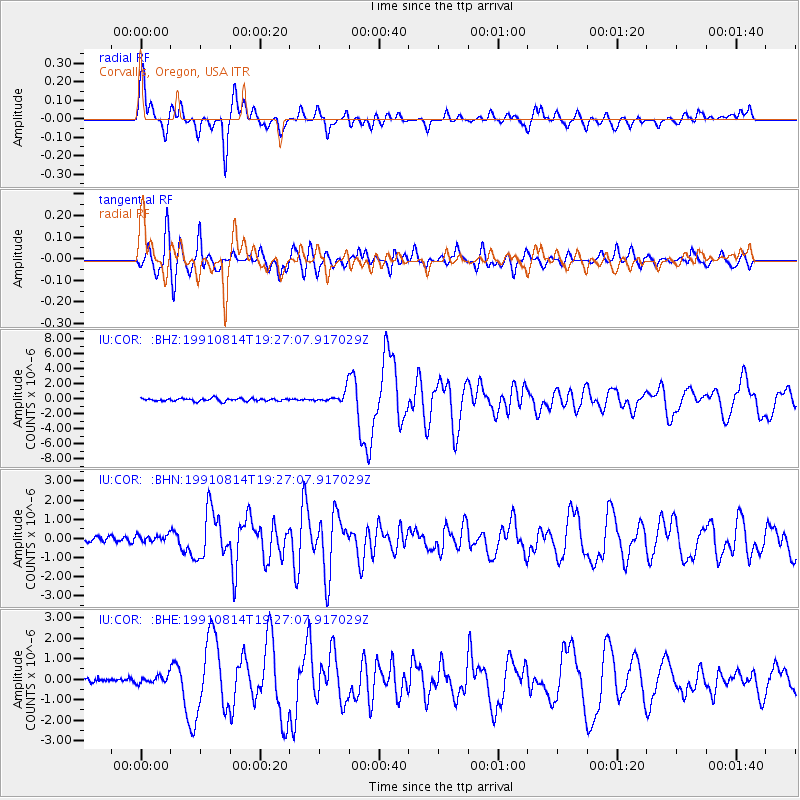
Signal To Noise
| Channel | StoN | STA | LTA |
| IU:COR: :BHN:19910814T19:27:07.917029Z | 1.3261907 | 2.1232958E-7 | 1.6010486E-7 |
| IU:COR: :BHE:19910814T19:27:07.917029Z | 1.2330269 | 1.8457875E-7 | 1.4969565E-7 |
| IU:COR: :BHZ:19910814T19:27:07.917029Z | 4.455886 | 8.190329E-7 | 1.8380922E-7 |
| Arrivals |
| Ps | 5.3 SECOND |
| PpPs | 16 SECOND |
| PsPs/PpSs | 21 SECOND |


