You are here: Home > Network List > IU - Global Seismograph Network (GSN - IRIS/USGS) Stations List
> Station COR Corvallis, Oregon, USA > Earthquake Result Viewer
COR Corvallis, Oregon, USA - Earthquake Result Viewer
| Earthquake location: |
Rat Islands, Aleutian Islands |
| Earthquake latitude/longitude: |
52.0/178.9 |
| Earthquake time(UTC): |
1991/01/23 (023) 01:12:30 GMT |
| Earthquake Depth: |
116 km |
| Earthquake Magnitude: |
5.9 MB |
| Earthquake Catalog/Contributor: |
WHDF/NEIC |
|
| Network: |
IU Global Seismograph Network (GSN - IRIS/USGS) |
| Station: |
COR Corvallis, Oregon, USA |
| Lat/Lon: |
44.59 N/123.30 W |
| Elevation: |
121 m |
|
| Distance: |
38.3 deg |
| Az: |
77.572 deg |
| Baz: |
302.371 deg |
| Ray Param: |
0.07525662 |
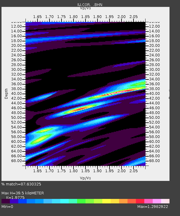
| Estimated Moho Depth: |
39.5 km |
| Estimated Crust Vp/Vs: |
1.98 |
| Assumed Crust Vp: |
6.566 km/s |
| Estimated Crust Vs: |
3.32 km/s |
| Estimated Crust Poisson's Ratio: |
0.33 |
|
| Radial Match: |
87.630325 % |
| Radial Bump: |
394 |
| Transverse Match: |
58.66213 % |
| Transverse Bump: |
400 |
| SOD ConfigId: |
17000 |
| Insert Time: |
2010-03-04 20:04:13.983 +0000 |
| GWidth: |
2.5 |
| Max Bumps: |
400 |
| Tol: |
0.001 |
|
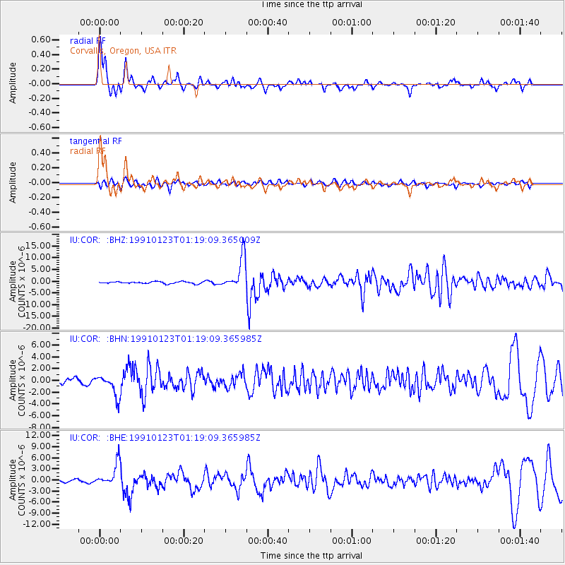
Signal To Noise
| Channel | StoN | STA | LTA |
| IU:COR: :BHN:19910123T01:19:09.365985Z | 3.6222403 | 1.8661232E-6 | 5.151848E-7 |
| IU:COR: :BHE:19910123T01:19:09.365985Z | 5.0030737 | 3.200176E-6 | 6.39642E-7 |
| IU:COR: :BHZ:19910123T01:19:09.365009Z | 17.139172 | 7.0798633E-6 | 4.130808E-7 |
| Arrivals |
| Ps | 6.3 SECOND |
| PpPs | 17 SECOND |
| PsPs/PpSs | 23 SECOND |


