You are here: Home > Network List > IU - Global Seismograph Network (GSN - IRIS/USGS) Stations List
> Station COR Corvallis, Oregon, USA > Earthquake Result Viewer
COR Corvallis, Oregon, USA - Earthquake Result Viewer
| Earthquake location: |
Southern East Pacific Rise |
| Earthquake latitude/longitude: |
-17.8/-116.0 |
| Earthquake time(UTC): |
1991/09/03 (246) 11:56:16 GMT |
| Earthquake Depth: |
10 km |
| Earthquake Magnitude: |
5.8 MB, 5.9 MS |
| Earthquake Catalog/Contributor: |
WHDF/NEIC |
|
| Network: |
IU Global Seismograph Network (GSN - IRIS/USGS) |
| Station: |
COR Corvallis, Oregon, USA |
| Lat/Lon: |
44.59 N/123.30 W |
| Elevation: |
121 m |
|
| Distance: |
62.5 deg |
| Az: |
354.091 deg |
| Baz: |
172.113 deg |
| Ray Param: |
0.060192183 |
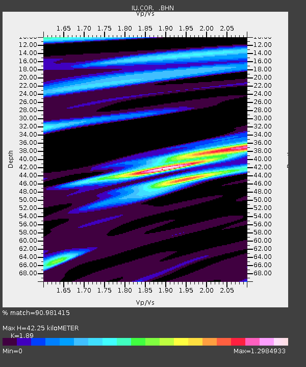
| Estimated Moho Depth: |
42.25 km |
| Estimated Crust Vp/Vs: |
1.89 |
| Assumed Crust Vp: |
6.566 km/s |
| Estimated Crust Vs: |
3.474 km/s |
| Estimated Crust Poisson's Ratio: |
0.31 |
|
| Radial Match: |
90.981415 % |
| Radial Bump: |
400 |
| Transverse Match: |
79.993835 % |
| Transverse Bump: |
400 |
| SOD ConfigId: |
17000 |
| Insert Time: |
2010-03-04 20:04:17.410 +0000 |
| GWidth: |
2.5 |
| Max Bumps: |
400 |
| Tol: |
0.001 |
|
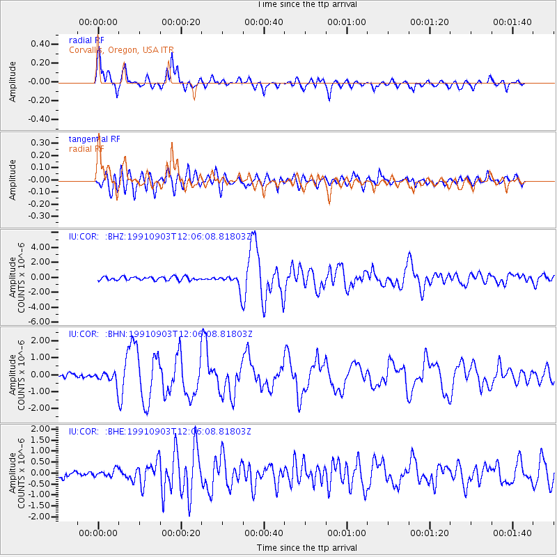
Signal To Noise
| Channel | StoN | STA | LTA |
| IU:COR: :BHN:19910903T12:06:08.81803Z | 2.7081175 | 3.6525472E-7 | 1.3487403E-7 |
| IU:COR: :BHE:19910903T12:06:08.81803Z | 0.9344655 | 1.6622076E-7 | 1.7787788E-7 |
| IU:COR: :BHZ:19910903T12:06:08.81803Z | 4.6989794 | 1.1126779E-6 | 2.3679138E-7 |
| Arrivals |
| Ps | 6.0 SECOND |
| PpPs | 18 SECOND |
| PsPs/PpSs | 24 SECOND |


