You are here: Home > Network List > IU - Global Seismograph Network (GSN - IRIS/USGS) Stations List
> Station COR Corvallis, Oregon, USA > Earthquake Result Viewer
COR Corvallis, Oregon, USA - Earthquake Result Viewer
| Earthquake location: |
Samoa Islands Region |
| Earthquake latitude/longitude: |
-16.5/-172.4 |
| Earthquake time(UTC): |
1992/05/12 (133) 18:05:45 GMT |
| Earthquake Depth: |
33 km |
| Earthquake Magnitude: |
6.3 MB, 6.8 MS |
| Earthquake Catalog/Contributor: |
WHDF/NEIC |
|
| Network: |
IU Global Seismograph Network (GSN - IRIS/USGS) |
| Station: |
COR Corvallis, Oregon, USA |
| Lat/Lon: |
44.59 N/123.30 W |
| Elevation: |
121 m |
|
| Distance: |
75.4 deg |
| Az: |
33.932 deg |
| Baz: |
228.557 deg |
| Ray Param: |
0.051639006 |
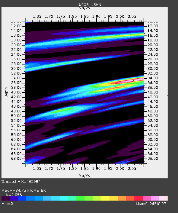
| Estimated Moho Depth: |
34.75 km |
| Estimated Crust Vp/Vs: |
2.06 |
| Assumed Crust Vp: |
6.566 km/s |
| Estimated Crust Vs: |
3.195 km/s |
| Estimated Crust Poisson's Ratio: |
0.34 |
|
| Radial Match: |
91.482994 % |
| Radial Bump: |
400 |
| Transverse Match: |
82.45974 % |
| Transverse Bump: |
400 |
| SOD ConfigId: |
16938 |
| Insert Time: |
2010-03-04 20:04:23.816 +0000 |
| GWidth: |
2.5 |
| Max Bumps: |
400 |
| Tol: |
0.001 |
|
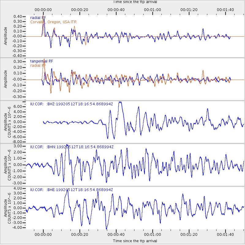
Signal To Noise
| Channel | StoN | STA | LTA |
| IU:COR: :BHN:19920512T18:16:54.868994Z | 0.69841546 | 2.2604614E-7 | 3.236557E-7 |
| IU:COR: :BHE:19920512T18:16:54.868994Z | 0.92072403 | 2.4306885E-7 | 2.6399752E-7 |
| IU:COR: :BHZ:19920512T18:16:54.868994Z | 3.952921 | 1.0142029E-6 | 2.565705E-7 |
| Arrivals |
| Ps | 5.7 SECOND |
| PpPs | 16 SECOND |
| PsPs/PpSs | 21 SECOND |


