You are here: Home > Network List > GS - US Geological Survey Networks Stations List
> Station KAN13 Rinehart Farm, , CA, USA > Earthquake Result Viewer
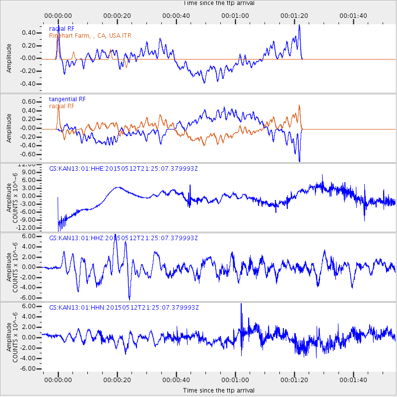
KAN13 Rinehart Farm, , CA, USA - Earthquake Result Viewer
*The percent match for this event was below the threshold and hence no stack was calculated.
| Earthquake location: |
Near East Coast Of Honshu, Japan |
| Earthquake latitude/longitude: |
38.9/142.0 |
| Earthquake time(UTC): |
2015/05/12 (132) 21:12:58 GMT |
| Earthquake Depth: |
39 km |
| Earthquake Magnitude: |
6.8 MWP, 6.8 MI |
| Earthquake Catalog/Contributor: |
NEIC PDE/NEIC COMCAT |
|
| Network: |
GS US Geological Survey Networks |
| Station: |
KAN13 Rinehart Farm, , CA, USA |
| Lat/Lon: |
37.01 N/97.48 W |
| Elevation: |
340 m |
|
| Distance: |
86.7 deg |
| Az: |
43.703 deg |
| Baz: |
317.661 deg |
| Ray Param: |
$rayparam |
*The percent match for this event was below the threshold and hence was not used in the summary stack. |
|
| Radial Match: |
24.654896 % |
| Radial Bump: |
400 |
| Transverse Match: |
18.247917 % |
| Transverse Bump: |
400 |
| SOD ConfigId: |
976571 |
| Insert Time: |
2015-05-26 21:27:45.305 +0000 |
| GWidth: |
2.5 |
| Max Bumps: |
400 |
| Tol: |
0.001 |
|
Signal To Noise
| Channel | StoN | STA | LTA |
| GS:KAN13:01:HHZ:20150512T21:25:07.379993Z | 5.9072824 | 1.2945966E-6 | 2.1915264E-7 |
| GS:KAN13:01:HHN:20150512T21:25:07.379993Z | 0.75953513 | 9.0253957E-7 | 1.1882789E-6 |
| GS:KAN13:01:HHE:20150512T21:25:07.379993Z | 0.7245997 | 3.179409E-6 | 4.3878144E-6 |
| Arrivals |
| Ps | |
| PpPs | |
| PsPs/PpSs | |


