You are here: Home > Network List > IU - Global Seismograph Network (GSN - IRIS/USGS) Stations List
> Station COR Corvallis, Oregon, USA > Earthquake Result Viewer
COR Corvallis, Oregon, USA - Earthquake Result Viewer
| Earthquake location: |
Northern Peru |
| Earthquake latitude/longitude: |
-3.9/-76.6 |
| Earthquake time(UTC): |
1992/07/13 (195) 18:11:34 GMT |
| Earthquake Depth: |
100 km |
| Earthquake Magnitude: |
6.2 MB |
| Earthquake Catalog/Contributor: |
WHDF/NEIC |
|
| Network: |
IU Global Seismograph Network (GSN - IRIS/USGS) |
| Station: |
COR Corvallis, Oregon, USA |
| Lat/Lon: |
44.59 N/123.30 W |
| Elevation: |
121 m |
|
| Distance: |
63.8 deg |
| Az: |
324.593 deg |
| Baz: |
126.007 deg |
| Ray Param: |
0.059070136 |
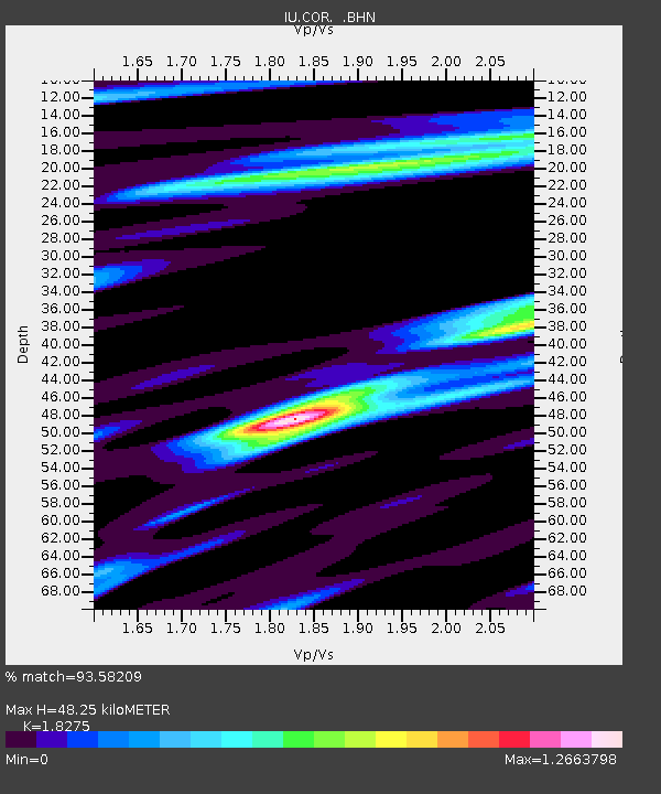
| Estimated Moho Depth: |
48.25 km |
| Estimated Crust Vp/Vs: |
1.83 |
| Assumed Crust Vp: |
6.566 km/s |
| Estimated Crust Vs: |
3.593 km/s |
| Estimated Crust Poisson's Ratio: |
0.29 |
|
| Radial Match: |
93.58209 % |
| Radial Bump: |
400 |
| Transverse Match: |
83.758255 % |
| Transverse Bump: |
400 |
| SOD ConfigId: |
16938 |
| Insert Time: |
2010-03-04 20:04:32.296 +0000 |
| GWidth: |
2.5 |
| Max Bumps: |
400 |
| Tol: |
0.001 |
|
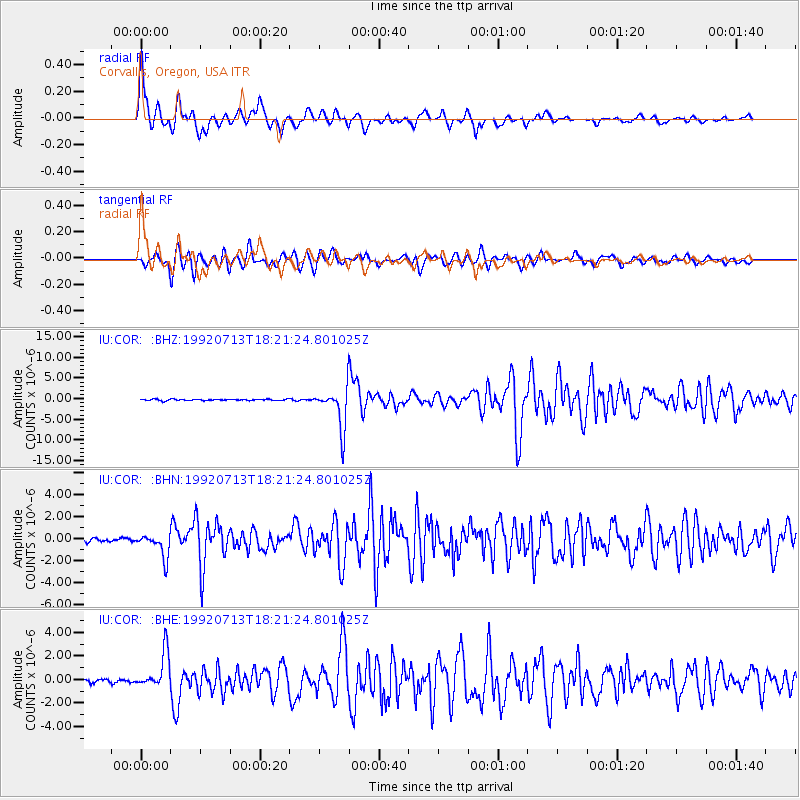
Signal To Noise
| Channel | StoN | STA | LTA |
| IU:COR: :BHN:19920713T18:21:24.801025Z | 6.9822197 | 1.0765054E-6 | 1.5417811E-7 |
| IU:COR: :BHE:19920713T18:21:24.801025Z | 10.420534 | 1.5364252E-6 | 1.4744208E-7 |
| IU:COR: :BHZ:19920713T18:21:24.801025Z | 29.208075 | 4.8290613E-6 | 1.6533309E-7 |
| Arrivals |
| Ps | 6.4 SECOND |
| PpPs | 20 SECOND |
| PsPs/PpSs | 26 SECOND |


