You are here: Home > Network List > IU - Global Seismograph Network (GSN - IRIS/USGS) Stations List
> Station COR Corvallis, Oregon, USA > Earthquake Result Viewer
COR Corvallis, Oregon, USA - Earthquake Result Viewer
| Earthquake location: |
Santa Cruz Islands |
| Earthquake latitude/longitude: |
-12.0/166.5 |
| Earthquake time(UTC): |
1992/08/04 (217) 21:08:44 GMT |
| Earthquake Depth: |
109 km |
| Earthquake Magnitude: |
5.9 MB |
| Earthquake Catalog/Contributor: |
WHDF/NEIC |
|
| Network: |
IU Global Seismograph Network (GSN - IRIS/USGS) |
| Station: |
COR Corvallis, Oregon, USA |
| Lat/Lon: |
44.59 N/123.30 W |
| Elevation: |
121 m |
|
| Distance: |
84.7 deg |
| Az: |
42.468 deg |
| Baz: |
247.583 deg |
| Ray Param: |
0.045041498 |
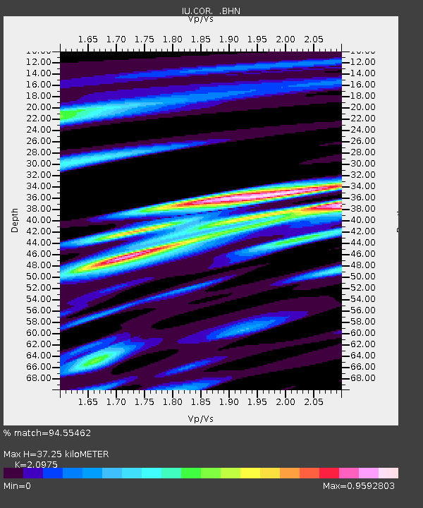
| Estimated Moho Depth: |
37.25 km |
| Estimated Crust Vp/Vs: |
2.10 |
| Assumed Crust Vp: |
6.566 km/s |
| Estimated Crust Vs: |
3.13 km/s |
| Estimated Crust Poisson's Ratio: |
0.35 |
|
| Radial Match: |
94.55462 % |
| Radial Bump: |
400 |
| Transverse Match: |
86.03559 % |
| Transverse Bump: |
400 |
| SOD ConfigId: |
17000 |
| Insert Time: |
2010-03-04 20:04:48.232 +0000 |
| GWidth: |
2.5 |
| Max Bumps: |
400 |
| Tol: |
0.001 |
|
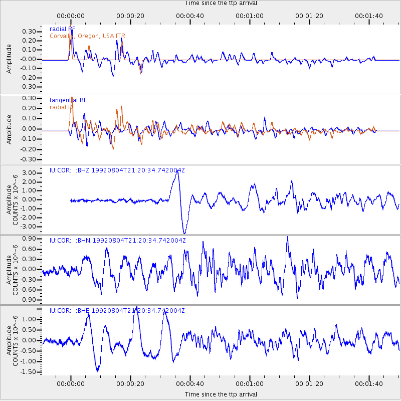
Signal To Noise
| Channel | StoN | STA | LTA |
| IU:COR: :BHN:19920804T21:20:34.742004Z | 1.4934046 | 1.6305485E-7 | 1.09183304E-7 |
| IU:COR: :BHE:19920804T21:20:34.742004Z | 2.2045147 | 2.1998461E-7 | 9.9788224E-8 |
| IU:COR: :BHZ:19920804T21:20:34.742004Z | 9.297933 | 9.2023765E-7 | 9.8972286E-8 |
| Arrivals |
| Ps | 6.4 SECOND |
| PpPs | 17 SECOND |
| PsPs/PpSs | 24 SECOND |


