You are here: Home > Network List > IU - Global Seismograph Network (GSN - IRIS/USGS) Stations List
> Station COR Corvallis, Oregon, USA > Earthquake Result Viewer
COR Corvallis, Oregon, USA - Earthquake Result Viewer
| Earthquake location: |
Near East Coast Of Kamchatka |
| Earthquake latitude/longitude: |
51.2/157.8 |
| Earthquake time(UTC): |
1993/06/08 (159) 13:03:37 GMT |
| Earthquake Depth: |
81 km |
| Earthquake Magnitude: |
6.4 MB, 7.3 MS |
| Earthquake Catalog/Contributor: |
WHDF/NEIC |
|
| Network: |
IU Global Seismograph Network (GSN - IRIS/USGS) |
| Station: |
COR Corvallis, Oregon, USA |
| Lat/Lon: |
44.59 N/123.30 W |
| Elevation: |
121 m |
|
| Distance: |
50.9 deg |
| Az: |
64.618 deg |
| Baz: |
307.329 deg |
| Ray Param: |
0.06751666 |
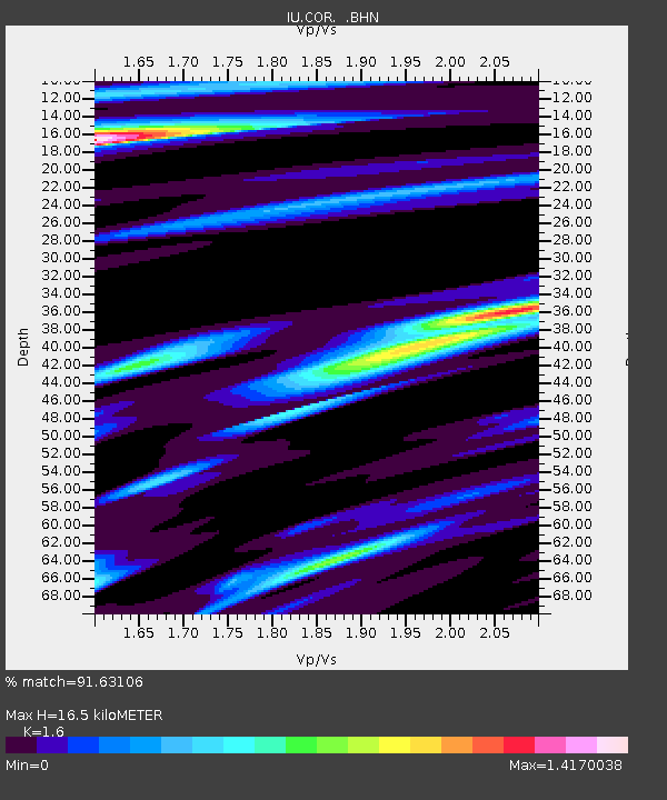
| Estimated Moho Depth: |
16.5 km |
| Estimated Crust Vp/Vs: |
1.60 |
| Assumed Crust Vp: |
6.566 km/s |
| Estimated Crust Vs: |
4.104 km/s |
| Estimated Crust Poisson's Ratio: |
0.18 |
|
| Radial Match: |
91.63106 % |
| Radial Bump: |
400 |
| Transverse Match: |
73.27255 % |
| Transverse Bump: |
400 |
| SOD ConfigId: |
16938 |
| Insert Time: |
2010-03-04 20:05:05.481 +0000 |
| GWidth: |
2.5 |
| Max Bumps: |
400 |
| Tol: |
0.001 |
|
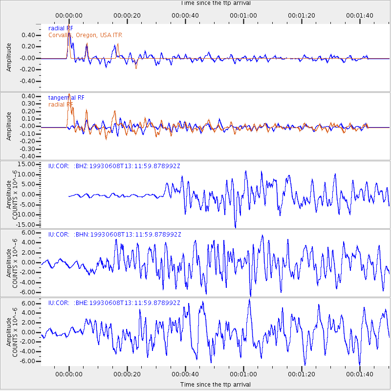
Signal To Noise
| Channel | StoN | STA | LTA |
| IU:COR: :BHN:19930608T13:11:59.878992Z | 1.2152376 | 5.217345E-7 | 4.2932714E-7 |
| IU:COR: :BHE:19930608T13:11:59.878992Z | 1.138393 | 6.2984515E-7 | 5.5327564E-7 |
| IU:COR: :BHZ:19930608T13:11:59.878992Z | 4.8041453 | 2.4770686E-6 | 5.156107E-7 |
| Arrivals |
| Ps | 1.6 SECOND |
| PpPs | 6.1 SECOND |
| PsPs/PpSs | 7.7 SECOND |


