You are here: Home > Network List > TA - USArray Transportable Network (new EarthScope stations) Stations List
> Station P60A Greenville, DE, USA > Earthquake Result Viewer
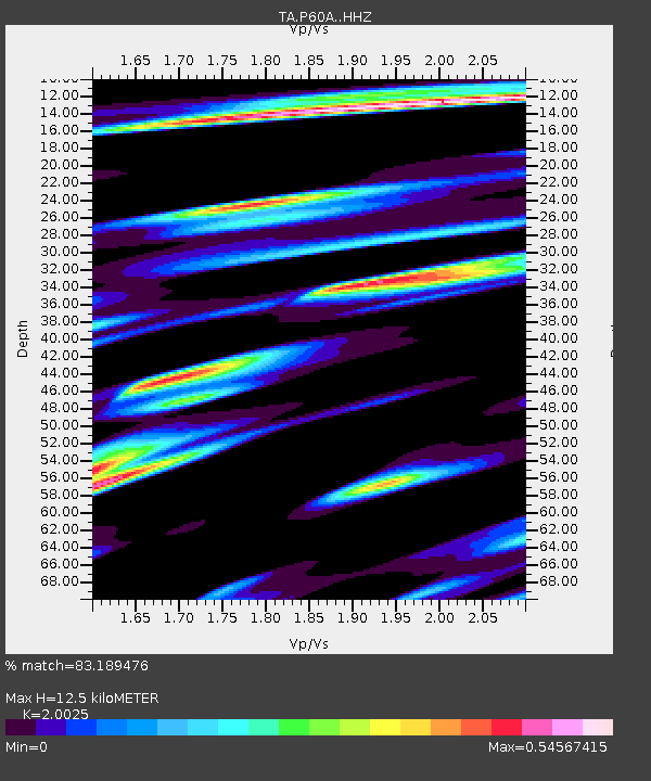
P60A Greenville, DE, USA - Earthquake Result Viewer
| Earthquake location: |
Off Coast Of Central Chile |
| Earthquake latitude/longitude: |
-32.4/-72.2 |
| Earthquake time(UTC): |
2015/09/18 (261) 09:10:44 GMT |
| Earthquake Depth: |
8.7 km |
| Earthquake Magnitude: |
6.3 MWP |
| Earthquake Catalog/Contributor: |
NEIC PDE/NEIC COMCAT |
|
| Network: |
TA USArray Transportable Network (new EarthScope stations) |
| Station: |
P60A Greenville, DE, USA |
| Lat/Lon: |
39.81 N/75.64 W |
| Elevation: |
105 m |
|
| Distance: |
71.9 deg |
| Az: |
357.245 deg |
| Baz: |
176.975 deg |
| Ray Param: |
0.054004747 |
| Estimated Moho Depth: |
12.5 km |
| Estimated Crust Vp/Vs: |
2.00 |
| Assumed Crust Vp: |
6.287 km/s |
| Estimated Crust Vs: |
3.14 km/s |
| Estimated Crust Poisson's Ratio: |
0.33 |
|
| Radial Match: |
83.189476 % |
| Radial Bump: |
400 |
| Transverse Match: |
62.109055 % |
| Transverse Bump: |
400 |
| SOD ConfigId: |
7422571 |
| Insert Time: |
2019-04-20 22:07:14.279 +0000 |
| GWidth: |
2.5 |
| Max Bumps: |
400 |
| Tol: |
0.001 |
|

Signal To Noise
| Channel | StoN | STA | LTA |
| TA:P60A: :HHZ:20150918T09:21:36.909973Z | 2.2549603 | 2.445119E-7 | 1.084329E-7 |
| TA:P60A: :HHN:20150918T09:21:36.909973Z | 1.2454954 | 1.1924386E-7 | 9.5740106E-8 |
| TA:P60A: :HHE:20150918T09:21:36.909973Z | 1.4075972 | 1.4094684E-7 | 1.00132944E-7 |
| Arrivals |
| Ps | 2.1 SECOND |
| PpPs | 5.8 SECOND |
| PsPs/PpSs | 7.8 SECOND |


