You are here: Home > Network List > TA - USArray Transportable Network (new EarthScope stations) Stations List
> Station WHTX Lake Whitney, Meridian, TX, USA > Earthquake Result Viewer
WHTX Lake Whitney, Meridian, TX, USA - Earthquake Result Viewer
| Earthquake location: |
Off Coast Of Central Chile |
| Earthquake latitude/longitude: |
-32.4/-72.2 |
| Earthquake time(UTC): |
2015/09/18 (261) 09:10:44 GMT |
| Earthquake Depth: |
8.7 km |
| Earthquake Magnitude: |
6.3 MWP |
| Earthquake Catalog/Contributor: |
NEIC PDE/NEIC COMCAT |
|
| Network: |
TA USArray Transportable Network (new EarthScope stations) |
| Station: |
WHTX Lake Whitney, Meridian, TX, USA |
| Lat/Lon: |
31.99 N/97.46 W |
| Elevation: |
190 m |
|
| Distance: |
68.3 deg |
| Az: |
337.072 deg |
| Baz: |
157.182 deg |
| Ray Param: |
0.056367356 |
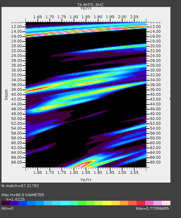
| Estimated Moho Depth: |
69.5 km |
| Estimated Crust Vp/Vs: |
1.82 |
| Assumed Crust Vp: |
6.347 km/s |
| Estimated Crust Vs: |
3.483 km/s |
| Estimated Crust Poisson's Ratio: |
0.28 |
|
| Radial Match: |
87.31792 % |
| Radial Bump: |
371 |
| Transverse Match: |
71.11596 % |
| Transverse Bump: |
400 |
| SOD ConfigId: |
7422571 |
| Insert Time: |
2019-04-20 22:07:17.300 +0000 |
| GWidth: |
2.5 |
| Max Bumps: |
400 |
| Tol: |
0.001 |
|

Signal To Noise
| Channel | StoN | STA | LTA |
| TA:WHTX: :BHZ:20150918T09:21:15.049988Z | 2.4173746 | 2.6155493E-7 | 1.0819794E-7 |
| TA:WHTX: :BHN:20150918T09:21:15.049988Z | 1.0832057 | 1.1706134E-7 | 1.0806935E-7 |
| TA:WHTX: :BHE:20150918T09:21:15.049988Z | 1.229647 | 1.8178335E-7 | 1.4783377E-7 |
| Arrivals |
| Ps | 9.3 SECOND |
| PpPs | 30 SECOND |
| PsPs/PpSs | 39 SECOND |


