You are here: Home > Network List > IU - Global Seismograph Network (GSN - IRIS/USGS) Stations List
> Station COR Corvallis, Oregon, USA > Earthquake Result Viewer
COR Corvallis, Oregon, USA - Earthquake Result Viewer
| Earthquake location: |
Near Coast Of Northern Chile |
| Earthquake latitude/longitude: |
-25.4/-70.2 |
| Earthquake time(UTC): |
1993/07/11 (192) 13:36:19 GMT |
| Earthquake Depth: |
33 km |
| Earthquake Magnitude: |
6.2 MB, 6.0 MS, 5.8 UNKNOWN, 6.8 MW |
| Earthquake Catalog/Contributor: |
WHDF/NEIC |
|
| Network: |
IU Global Seismograph Network (GSN - IRIS/USGS) |
| Station: |
COR Corvallis, Oregon, USA |
| Lat/Lon: |
44.59 N/123.30 W |
| Elevation: |
121 m |
|
| Distance: |
84.8 deg |
| Az: |
324.974 deg |
| Baz: |
133.384 deg |
| Ray Param: |
0.045155697 |
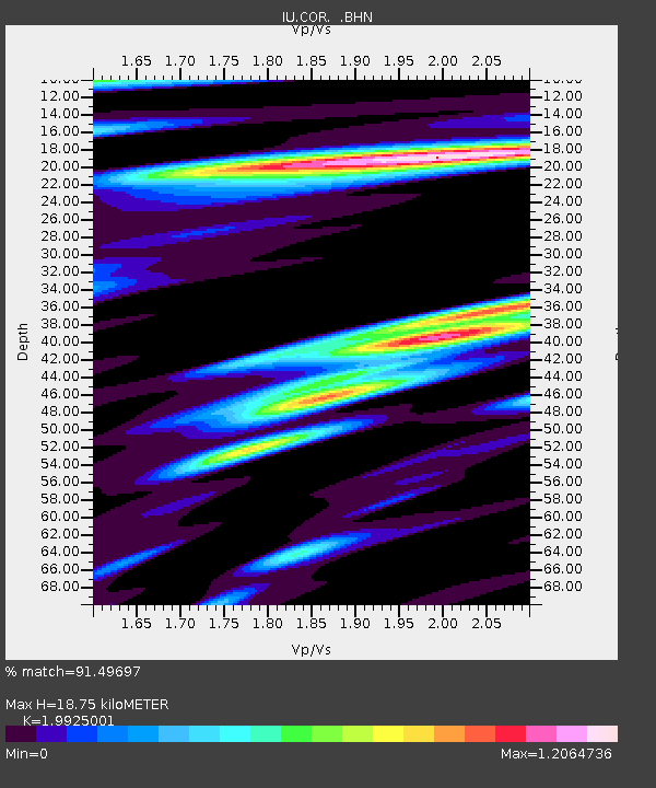
| Estimated Moho Depth: |
18.75 km |
| Estimated Crust Vp/Vs: |
1.99 |
| Assumed Crust Vp: |
6.566 km/s |
| Estimated Crust Vs: |
3.295 km/s |
| Estimated Crust Poisson's Ratio: |
0.33 |
|
| Radial Match: |
91.49697 % |
| Radial Bump: |
400 |
| Transverse Match: |
78.37126 % |
| Transverse Bump: |
400 |
| SOD ConfigId: |
16938 |
| Insert Time: |
2010-03-04 20:05:08.672 +0000 |
| GWidth: |
2.5 |
| Max Bumps: |
400 |
| Tol: |
0.001 |
|
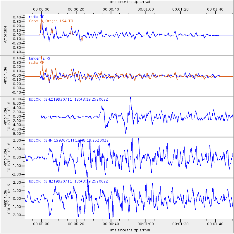
Signal To Noise
| Channel | StoN | STA | LTA |
| IU:COR: :BHN:19930711T13:48:19.252002Z | 1.2496355 | 3.4472666E-7 | 2.758618E-7 |
| IU:COR: :BHE:19930711T13:48:19.252002Z | 1.6436938 | 6.622738E-7 | 4.02918E-7 |
| IU:COR: :BHZ:19930711T13:48:19.252002Z | 5.1162024 | 1.6130818E-6 | 3.1528893E-7 |
| Arrivals |
| Ps | 2.9 SECOND |
| PpPs | 8.4 SECOND |
| PsPs/PpSs | 11 SECOND |


