You are here: Home > Network List > IU - Global Seismograph Network (GSN - IRIS/USGS) Stations List
> Station COR Corvallis, Oregon, USA > Earthquake Result Viewer
COR Corvallis, Oregon, USA - Earthquake Result Viewer
| Earthquake location: |
Hokkaido, Japan Region |
| Earthquake latitude/longitude: |
42.8/139.2 |
| Earthquake time(UTC): |
1993/07/12 (193) 13:17:11 GMT |
| Earthquake Depth: |
17 km |
| Earthquake Magnitude: |
6.7 MB, 7.6 MS, 7.3 UNKNOWN, 7.8 MW |
| Earthquake Catalog/Contributor: |
WHDF/NEIC |
|
| Network: |
IU Global Seismograph Network (GSN - IRIS/USGS) |
| Station: |
COR Corvallis, Oregon, USA |
| Lat/Lon: |
44.59 N/123.30 W |
| Elevation: |
121 m |
|
| Distance: |
66.1 deg |
| Az: |
50.826 deg |
| Baz: |
307.063 deg |
| Ray Param: |
0.057851247 |
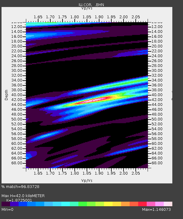
| Estimated Moho Depth: |
42.0 km |
| Estimated Crust Vp/Vs: |
1.87 |
| Assumed Crust Vp: |
6.566 km/s |
| Estimated Crust Vs: |
3.507 km/s |
| Estimated Crust Poisson's Ratio: |
0.30 |
|
| Radial Match: |
96.83728 % |
| Radial Bump: |
330 |
| Transverse Match: |
92.15433 % |
| Transverse Bump: |
400 |
| SOD ConfigId: |
16938 |
| Insert Time: |
2010-03-04 20:05:10.728 +0000 |
| GWidth: |
2.5 |
| Max Bumps: |
400 |
| Tol: |
0.001 |
|
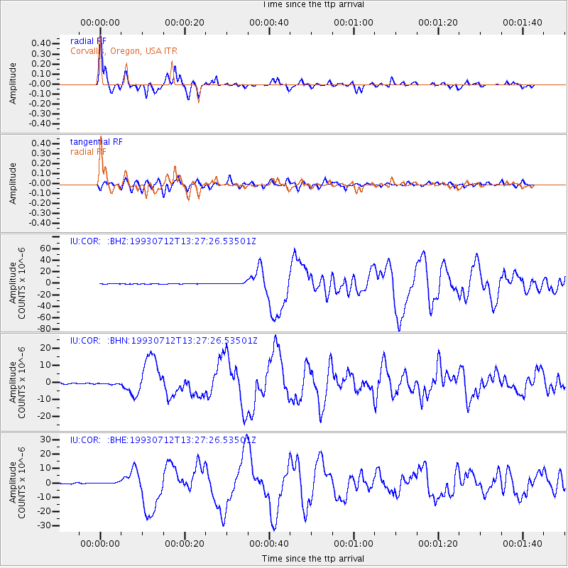
Signal To Noise
| Channel | StoN | STA | LTA |
| IU:COR: :BHN:19930712T13:27:26.53501Z | 1.2803057 | 4.2377985E-7 | 3.3099894E-7 |
| IU:COR: :BHE:19930712T13:27:26.53501Z | 2.100331 | 6.097356E-7 | 2.9030454E-7 |
| IU:COR: :BHZ:19930712T13:27:26.53501Z | 5.993435 | 1.858955E-6 | 3.101652E-7 |
| Arrivals |
| Ps | 5.8 SECOND |
| PpPs | 18 SECOND |
| PsPs/PpSs | 23 SECOND |


