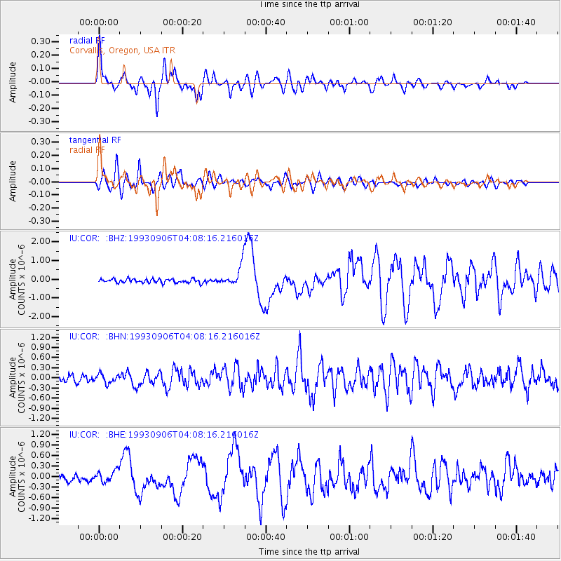
COR Corvallis, Oregon, USA - Earthquake Result Viewer
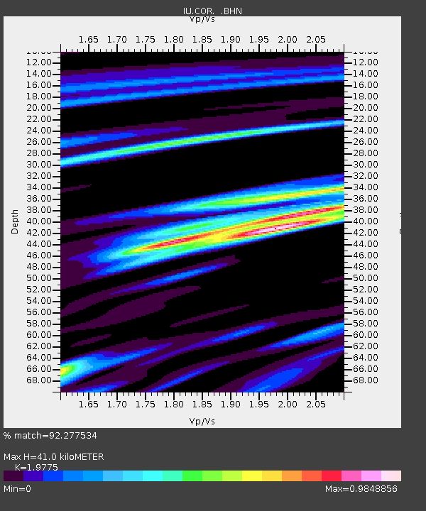
Earthquake location: New Ireland Region, P.N.G.
Earthquake latitude/longitude: -4.7/153.2
Earthquake time(UTC): 1993/09/06 (249) 03:56:02 GMT
Earthquake Depth: 73 km
Earthquake Magnitude: 6.0 MB, 6.6 MS, 6.7 UNKNOWN, 6.6 MW
Earthquake Catalog/Contributor: WHDF/NEIC
Network: IU Global Seismograph Network (GSN - IRIS/USGS)
Station: COR Corvallis, Oregon, USA
Lat/Lon: 44.59 N/123.30 W
Elevation: 121 m
Distance: 88.6 deg
Az: 45.246 deg
Baz: 262.099 deg
Ray Param: 0.042295262
Estimated Moho Depth: 41.0 km
Estimated Crust Vp/Vs: 1.98
Assumed Crust Vp: 6.566 km/s
Estimated Crust Vs: 3.32 km/s
Estimated Crust Poisson's Ratio: 0.33
Radial Match: 92.277534 %
Radial Bump: 400
Transverse Match: 85.473305 %
Transverse Bump: 400
SOD ConfigId: 16938
Insert Time: 2010-03-04 20:05:15.156 +0000
GWidth: 2.5
Max Bumps: 400
Tol: 0.001

Signal To Noise

ChannelStoNSTALTA
IU:COR: :BHN:19930906T04:08:16.216016Z1.43911681.3675768E-79.5028895E-8
IU:COR: :BHE:19930906T04:08:16.216016Z1.74739181.6575684E-79.485958E-8
IU:COR: :BHZ:19930906T04:08:16.216016Z6.21763376.2077265E-79.984066E-8
Arrivals
Ps6.2 SECOND
PpPs18 SECOND
PsPs/PpSs24 SECOND