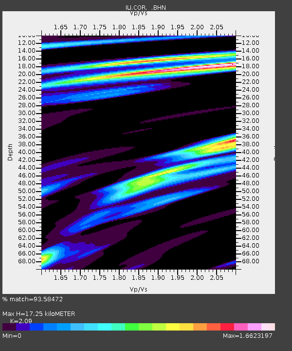
COR Corvallis, Oregon, USA - Earthquake Result Viewer
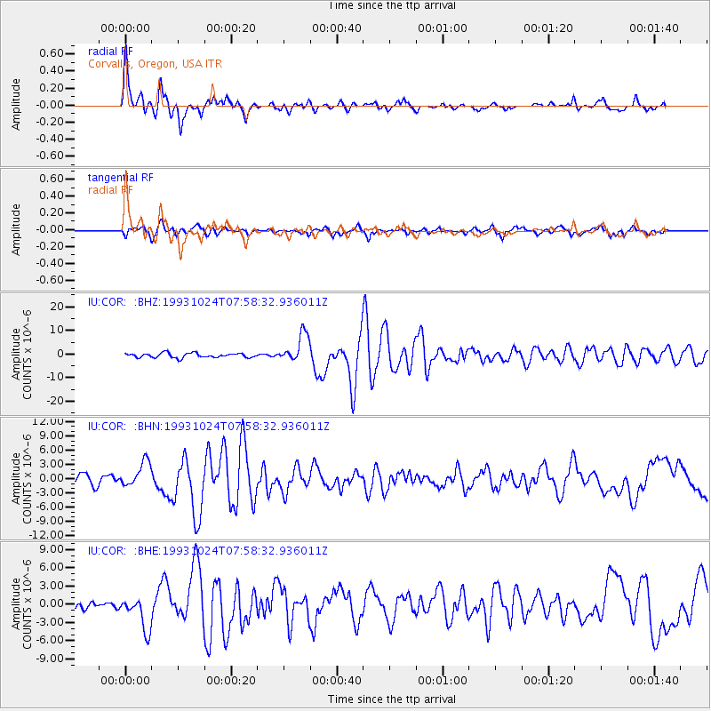
Earthquake location: Near Coast Of Guerrero, Mexico
Earthquake latitude/longitude: 16.8/-98.7
Earthquake time(UTC): 1993/10/24 (297) 07:52:17 GMT
Earthquake Depth: 32 km
Earthquake Magnitude: 6.2 MB, 6.6 MS, 6.5 UNKNOWN, 6.8 MW
Earthquake Catalog/Contributor: WHDF/NEIC
Network: IU Global Seismograph Network (GSN - IRIS/USGS)
Station: COR Corvallis, Oregon, USA
Lat/Lon: 44.59 N/123.30 W
Elevation: 121 m
Distance: 34.6 deg
Az: 328.435 deg
Baz: 135.43 deg
Ray Param: 0.07760498
Estimated Moho Depth: 17.25 km
Estimated Crust Vp/Vs: 2.09
Assumed Crust Vp: 6.566 km/s
Estimated Crust Vs: 3.142 km/s
Estimated Crust Poisson's Ratio: 0.35
Radial Match: 93.58472 %
Radial Bump: 400
Transverse Match: 85.34296 %
Transverse Bump: 400
SOD ConfigId: 16938
Insert Time: 2010-03-04 20:05:23.966 +0000
GWidth: 2.5
Max Bumps: 400
Tol: 0.001

Signal To Noise

ChannelStoNSTALTA
IU:COR: :BHN:19931024T07:58:32.936011Z2.74826362.7140738E-69.875595E-7
IU:COR: :BHE:19931024T07:58:32.936011Z2.8692722.8391462E-69.895006E-7
IU:COR: :BHZ:19931024T07:58:32.936011Z6.42931276.115098E-69.5112784E-7
Arrivals
Ps3.1 SECOND
PpPs7.6 SECOND
PsPs/PpSs11 SECOND