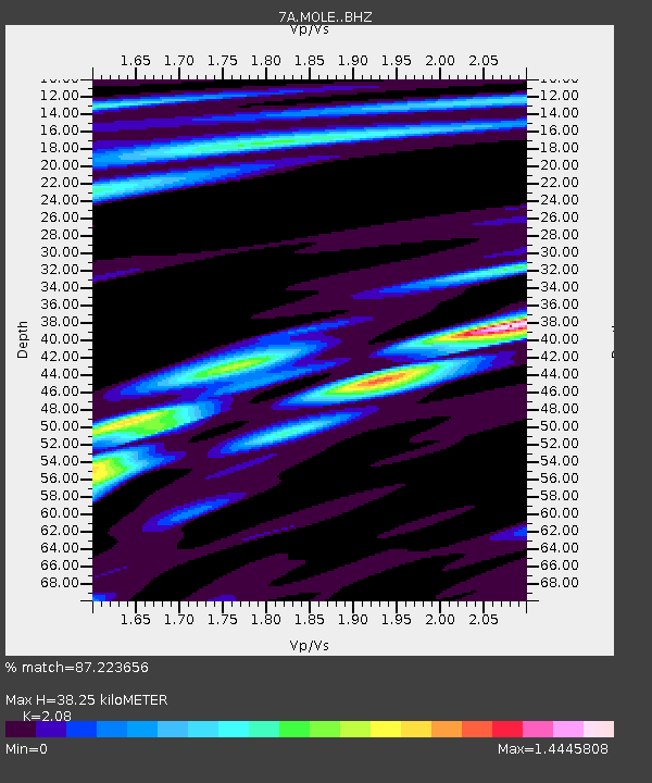
MOLE Hinton, Virginia USA - Earthquake Result Viewer

Earthquake location: Northern Mid-Atlantic Ridge
Earthquake latitude/longitude: 15.3/-46.0
Earthquake time(UTC): 2015/09/18 (261) 15:59:42 GMT
Earthquake Depth: 10 km
Earthquake Magnitude: 6.0 MWW, 5.9 MWB, 6.0 MWC
Earthquake Catalog/Contributor: NEIC PDE/NEIC COMCAT
Network: 7A Mid-Atlantic Geophysical Integrative Collaboration
Station: MOLE Hinton, Virginia USA
Lat/Lon: 38.49 N/79.02 W
Elevation: 487 m
Distance: 37.1 deg
Az: 314.88 deg
Baz: 119.371 deg
Ray Param: 0.07630331
Estimated Moho Depth: 38.25 km
Estimated Crust Vp/Vs: 2.08
Assumed Crust Vp: 6.159 km/s
Estimated Crust Vs: 2.961 km/s
Estimated Crust Poisson's Ratio: 0.35
Radial Match: 87.223656 %
Radial Bump: 354
Transverse Match: 58.741386 %
Transverse Bump: 400
SOD ConfigId: 7422571
Insert Time: 2019-04-20 22:09:25.270 +0000
GWidth: 2.5
Max Bumps: 400
Tol: 0.001

Signal To Noise

ChannelStoNSTALTA
7A:MOLE: :BHZ:20150918T16:06:22.534989Z2.95126824.965216E-71.6824008E-7
7A:MOLE: :BHN:20150918T16:06:22.534989Z2.40213042.3432362E-79.754825E-8
7A:MOLE: :BHE:20150918T16:06:22.534989Z3.22820072.570406E-77.962348E-8
Arrivals
Ps7.1 SECOND
PpPs18 SECOND
PsPs/PpSs25 SECOND