You are here: Home > Network List > IU - Global Seismograph Network (GSN - IRIS/USGS) Stations List
> Station COR Corvallis, Oregon, USA > Earthquake Result Viewer
COR Corvallis, Oregon, USA - Earthquake Result Viewer
| Earthquake location: |
Fiji Islands Region |
| Earthquake latitude/longitude: |
-17.8/-178.5 |
| Earthquake time(UTC): |
1994/03/09 (068) 23:28:07 GMT |
| Earthquake Depth: |
564 km |
| Earthquake Magnitude: |
6.6 MB, 7.6 UNKNOWN, 7.6 MW |
| Earthquake Catalog/Contributor: |
WHDF/NEIC |
|
| Network: |
IU Global Seismograph Network (GSN - IRIS/USGS) |
| Station: |
COR Corvallis, Oregon, USA |
| Lat/Lon: |
44.59 N/123.30 W |
| Elevation: |
121 m |
|
| Distance: |
79.8 deg |
| Az: |
36.591 deg |
| Baz: |
232.649 deg |
| Ray Param: |
0.04696831 |
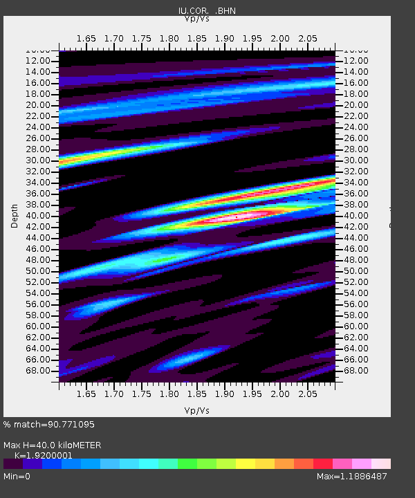
| Estimated Moho Depth: |
40.0 km |
| Estimated Crust Vp/Vs: |
1.92 |
| Assumed Crust Vp: |
6.566 km/s |
| Estimated Crust Vs: |
3.42 km/s |
| Estimated Crust Poisson's Ratio: |
0.31 |
|
| Radial Match: |
90.771095 % |
| Radial Bump: |
400 |
| Transverse Match: |
87.99646 % |
| Transverse Bump: |
400 |
| SOD ConfigId: |
16938 |
| Insert Time: |
2010-03-04 20:05:32.963 +0000 |
| GWidth: |
2.5 |
| Max Bumps: |
400 |
| Tol: |
0.001 |
|
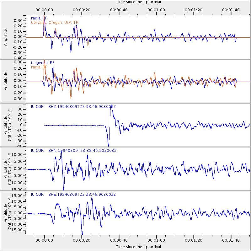
Signal To Noise
| Channel | StoN | STA | LTA |
| IU:COR: :BHN:19940309T23:38:46.903003Z | 11.926516 | 2.7444378E-6 | 2.3011228E-7 |
| IU:COR: :BHE:19940309T23:38:46.903003Z | 13.490004 | 2.8106667E-6 | 2.083518E-7 |
| IU:COR: :BHZ:19940309T23:38:46.903003Z | 46.04549 | 1.4366886E-5 | 3.1201506E-7 |
| Arrivals |
| Ps | 5.7 SECOND |
| PpPs | 17 SECOND |
| PsPs/PpSs | 23 SECOND |


