You are here: Home > Network List > IU - Global Seismograph Network (GSN - IRIS/USGS) Stations List
> Station COR Corvallis, Oregon, USA > Earthquake Result Viewer
COR Corvallis, Oregon, USA - Earthquake Result Viewer
| Earthquake location: |
Mexico-Guatemala Border Region |
| Earthquake latitude/longitude: |
16.0/-92.4 |
| Earthquake time(UTC): |
1994/03/14 (073) 20:51:25 GMT |
| Earthquake Depth: |
169 km |
| Earthquake Magnitude: |
5.9 MB, 6.2 MS, 6.9 UNKNOWN, 6.2 MD |
| Earthquake Catalog/Contributor: |
WHDF/NEIC |
|
| Network: |
IU Global Seismograph Network (GSN - IRIS/USGS) |
| Station: |
COR Corvallis, Oregon, USA |
| Lat/Lon: |
44.59 N/123.30 W |
| Elevation: |
121 m |
|
| Distance: |
38.6 deg |
| Az: |
324.005 deg |
| Baz: |
127.71 deg |
| Ray Param: |
0.07482859 |
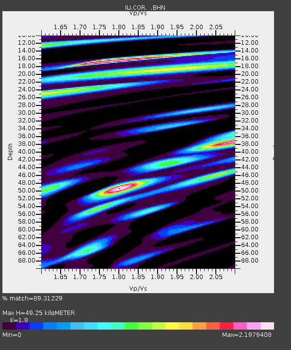
| Estimated Moho Depth: |
49.25 km |
| Estimated Crust Vp/Vs: |
1.80 |
| Assumed Crust Vp: |
6.566 km/s |
| Estimated Crust Vs: |
3.648 km/s |
| Estimated Crust Poisson's Ratio: |
0.28 |
|
| Radial Match: |
89.31229 % |
| Radial Bump: |
400 |
| Transverse Match: |
79.64542 % |
| Transverse Bump: |
400 |
| SOD ConfigId: |
16938 |
| Insert Time: |
2010-03-04 20:05:34.245 +0000 |
| GWidth: |
2.5 |
| Max Bumps: |
400 |
| Tol: |
0.001 |
|
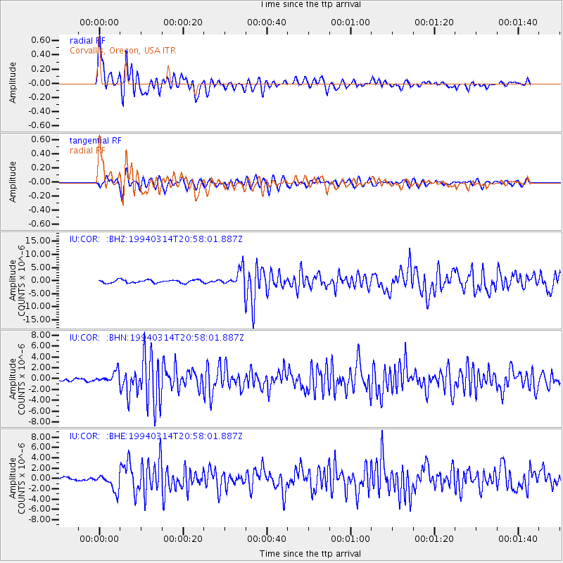
Signal To Noise
| Channel | StoN | STA | LTA |
| IU:COR: :BHN:19940314T20:58:01.887Z | 3.4212763 | 1.083303E-6 | 3.166371E-7 |
| IU:COR: :BHE:19940314T20:58:01.887Z | 5.18922 | 1.6275686E-6 | 3.1364416E-7 |
| IU:COR: :BHZ:19940314T20:58:01.887Z | 6.1780577 | 3.5321505E-6 | 5.717251E-7 |
| Arrivals |
| Ps | 6.5 SECOND |
| PpPs | 20 SECOND |
| PsPs/PpSs | 26 SECOND |


